You are here: Home > Network List > US - United States National Seismic Network Stations List
> Station DGMT Dagmar, Montana, USA > Earthquake Result Viewer
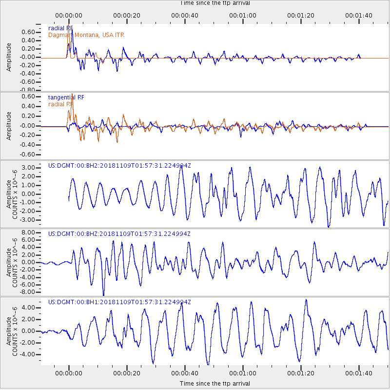
DGMT Dagmar, Montana, USA - Earthquake Result Viewer
*The percent match for this event was below the threshold and hence no stack was calculated.
| Earthquake location: |
Jan Mayen Island Region |
| Earthquake latitude/longitude: |
71.6/-11.2 |
| Earthquake time(UTC): |
2018/11/09 (313) 01:49:40 GMT |
| Earthquake Depth: |
10 km |
| Earthquake Magnitude: |
6.8 Mww |
| Earthquake Catalog/Contributor: |
NEIC PDE/us |
|
| Network: |
US United States National Seismic Network |
| Station: |
DGMT Dagmar, Montana, USA |
| Lat/Lon: |
48.47 N/104.20 W |
| Elevation: |
0.0 m |
|
| Distance: |
45.8 deg |
| Az: |
292.056 deg |
| Baz: |
26.214 deg |
| Ray Param: |
$rayparam |
*The percent match for this event was below the threshold and hence was not used in the summary stack. |
|
| Radial Match: |
90.87571 % |
| Radial Bump: |
341 |
| Transverse Match: |
71.358345 % |
| Transverse Bump: |
378 |
| SOD ConfigId: |
3131071 |
| Insert Time: |
2018-11-23 02:02:08.206 +0000 |
| GWidth: |
2.5 |
| Max Bumps: |
400 |
| Tol: |
0.001 |
|
Signal To Noise
| Channel | StoN | STA | LTA |
| US:DGMT:00:BHZ:20181109T01:57:31.224994Z | 7.245495 | 2.2004149E-6 | 3.036942E-7 |
| US:DGMT:00:BH1:20181109T01:57:31.224994Z | 1.5109614 | 9.4482084E-7 | 6.2531103E-7 |
| US:DGMT:00:BH2:20181109T01:57:31.224994Z | 1.4617183 | 1.3761291E-6 | 9.4144616E-7 |
| Arrivals |
| Ps | |
| PpPs | |
| PsPs/PpSs | |


