You are here: Home > Network List > US - United States National Seismic Network Stations List
> Station EYMN Ely, Minnesota, USA > Earthquake Result Viewer
EYMN Ely, Minnesota, USA - Earthquake Result Viewer
| Earthquake location: |
Jan Mayen Island Region |
| Earthquake latitude/longitude: |
71.6/-11.2 |
| Earthquake time(UTC): |
2018/11/09 (313) 01:49:40 GMT |
| Earthquake Depth: |
10 km |
| Earthquake Magnitude: |
6.8 Mww |
| Earthquake Catalog/Contributor: |
NEIC PDE/us |
|
| Network: |
US United States National Seismic Network |
| Station: |
EYMN Ely, Minnesota, USA |
| Lat/Lon: |
47.95 N/91.50 W |
| Elevation: |
475 m |
|
| Distance: |
42.4 deg |
| Az: |
280.841 deg |
| Baz: |
27.605 deg |
| Ray Param: |
0.07318128 |
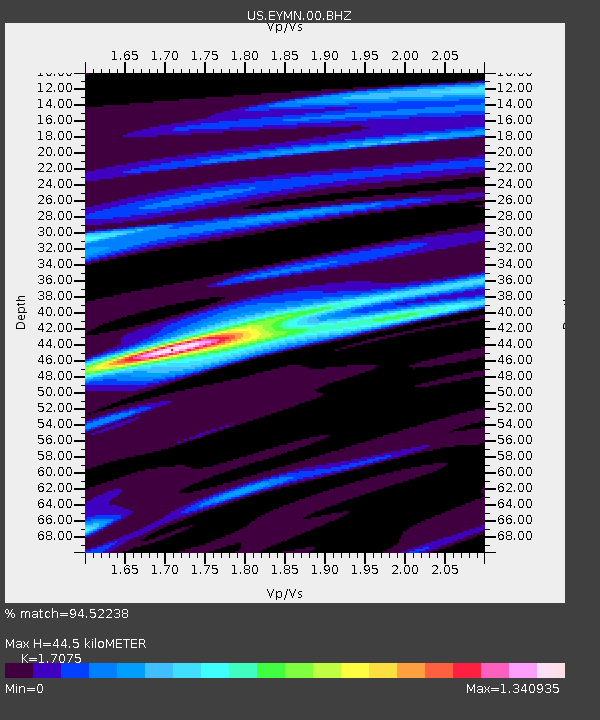
| Estimated Moho Depth: |
44.5 km |
| Estimated Crust Vp/Vs: |
1.71 |
| Assumed Crust Vp: |
6.467 km/s |
| Estimated Crust Vs: |
3.787 km/s |
| Estimated Crust Poisson's Ratio: |
0.24 |
|
| Radial Match: |
94.52238 % |
| Radial Bump: |
304 |
| Transverse Match: |
77.19098 % |
| Transverse Bump: |
400 |
| SOD ConfigId: |
3131071 |
| Insert Time: |
2018-11-23 02:02:18.490 +0000 |
| GWidth: |
2.5 |
| Max Bumps: |
400 |
| Tol: |
0.001 |
|

Signal To Noise
| Channel | StoN | STA | LTA |
| US:EYMN:00:BHZ:20181109T01:57:04.099994Z | 3.4115808 | 8.259433E-7 | 2.4209987E-7 |
| US:EYMN:00:BH1:20181109T01:57:04.099994Z | 1.7572424 | 5.2288783E-7 | 2.975616E-7 |
| US:EYMN:00:BH2:20181109T01:57:04.099994Z | 2.1632636 | 4.6035052E-7 | 2.1280371E-7 |
| Arrivals |
| Ps | 5.2 SECOND |
| PpPs | 17 SECOND |
| PsPs/PpSs | 23 SECOND |


