You are here: Home > Network List > US - United States National Seismic Network Stations List
> Station HAWA Hanford, Washington, USA > Earthquake Result Viewer
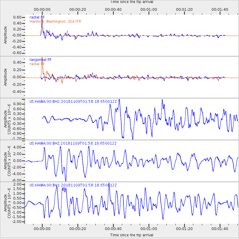
HAWA Hanford, Washington, USA - Earthquake Result Viewer

| Earthquake location: |
Jan Mayen Island Region |
| Earthquake latitude/longitude: |
71.6/-11.2 |
| Earthquake time(UTC): |
2018/11/09 (313) 01:49:40 GMT |
| Earthquake Depth: |
10 km |
| Earthquake Magnitude: |
6.8 Mww |
| Earthquake Catalog/Contributor: |
NEIC PDE/us |
|
| Network: |
US United States National Seismic Network |
| Station: |
HAWA Hanford, Washington, USA |
| Lat/Lon: |
46.39 N/119.53 W |
| Elevation: |
364 m |
|
| Distance: |
52.0 deg |
| Az: |
303.5 deg |
| Baz: |
22.467 deg |
| Ray Param: |
0.06703932 |
| Estimated Moho Depth: |
65.25 km |
| Estimated Crust Vp/Vs: |
1.93 |
| Assumed Crust Vp: |
6.419 km/s |
| Estimated Crust Vs: |
3.326 km/s |
| Estimated Crust Poisson's Ratio: |
0.32 |
|
| Radial Match: |
94.38728 % |
| Radial Bump: |
400 |
| Transverse Match: |
80.833206 % |
| Transverse Bump: |
305 |
| SOD ConfigId: |
3131071 |
| Insert Time: |
2018-11-23 02:02:21.572 +0000 |
| GWidth: |
2.5 |
| Max Bumps: |
400 |
| Tol: |
0.001 |
|
Signal To Noise
| Channel | StoN | STA | LTA |
| US:HAWA:00:BHZ:20181109T01:58:18.650012Z | 19.22485 | 1.755916E-6 | 9.133575E-8 |
| US:HAWA:00:BH1:20181109T01:58:18.650012Z | 6.3266125 | 8.140093E-7 | 1.2866433E-7 |
| US:HAWA:00:BH2:20181109T01:58:18.650012Z | 3.5911598 | 3.029444E-7 | 8.435837E-8 |
| Arrivals |
| Ps | 9.9 SECOND |
| PpPs | 28 SECOND |
| PsPs/PpSs | 38 SECOND |


