You are here: Home > Network List > US - United States National Seismic Network Stations List
> Station MSO Missoula, Montana, USA > Earthquake Result Viewer
MSO Missoula, Montana, USA - Earthquake Result Viewer
| Earthquake location: |
Jan Mayen Island Region |
| Earthquake latitude/longitude: |
71.6/-11.2 |
| Earthquake time(UTC): |
2018/11/09 (313) 01:49:40 GMT |
| Earthquake Depth: |
10 km |
| Earthquake Magnitude: |
6.8 Mww |
| Earthquake Catalog/Contributor: |
NEIC PDE/us |
|
| Network: |
US United States National Seismic Network |
| Station: |
MSO Missoula, Montana, USA |
| Lat/Lon: |
46.83 N/113.94 W |
| Elevation: |
1264 m |
|
| Distance: |
50.1 deg |
| Az: |
299.162 deg |
| Baz: |
23.791 deg |
| Ray Param: |
0.06828652 |
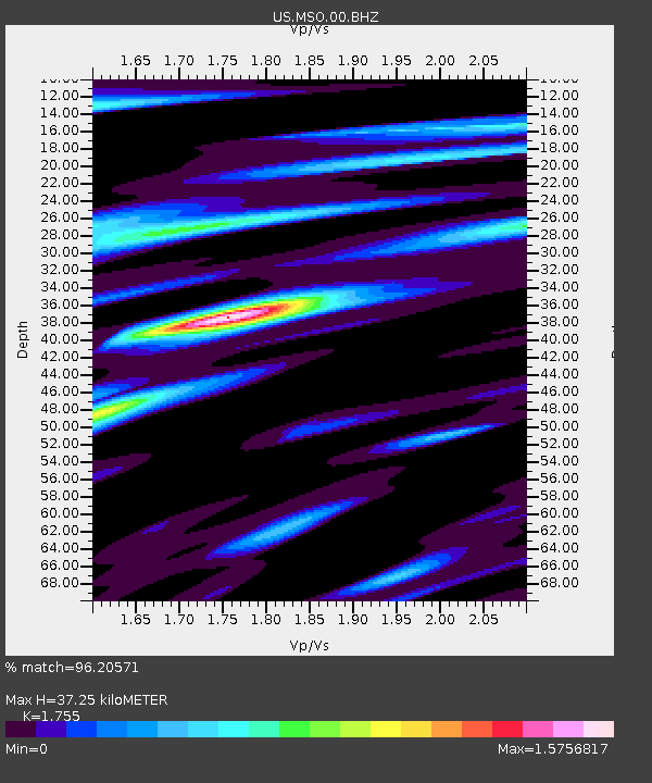
| Estimated Moho Depth: |
37.25 km |
| Estimated Crust Vp/Vs: |
1.75 |
| Assumed Crust Vp: |
6.353 km/s |
| Estimated Crust Vs: |
3.62 km/s |
| Estimated Crust Poisson's Ratio: |
0.26 |
|
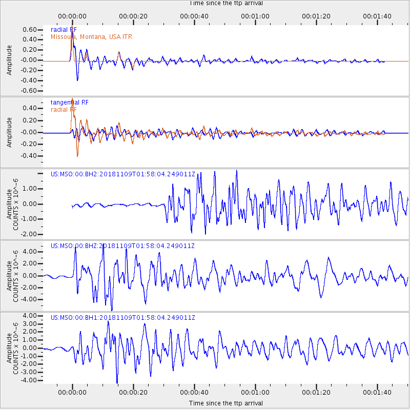
| Radial Match: |
96.20571 % |
| Radial Bump: |
348 |
| Transverse Match: |
90.59615 % |
| Transverse Bump: |
400 |
| SOD ConfigId: |
3131071 |
| Insert Time: |
2018-11-23 02:02:42.004 +0000 |
| GWidth: |
2.5 |
| Max Bumps: |
400 |
| Tol: |
0.001 |
|
Signal To Noise
| Channel | StoN | STA | LTA |
| US:MSO:00:BHZ:20181109T01:58:04.249011Z | 11.219731 | 1.7630948E-6 | 1.5714234E-7 |
| US:MSO:00:BH1:20181109T01:58:04.249011Z | 6.9279313 | 9.88727E-7 | 1.4271605E-7 |
| US:MSO:00:BH2:20181109T01:58:04.249011Z | 9.682814 | 6.697469E-7 | 6.916862E-8 |
| Arrivals |
| Ps | 4.7 SECOND |
| PpPs | 15 SECOND |
| PsPs/PpSs | 20 SECOND |


