You are here: Home > Network List > US - United States National Seismic Network Stations List
> Station RLMT Red Lodge, Montana, USA > Earthquake Result Viewer
RLMT Red Lodge, Montana, USA - Earthquake Result Viewer
| Earthquake location: |
Jan Mayen Island Region |
| Earthquake latitude/longitude: |
71.6/-11.2 |
| Earthquake time(UTC): |
2018/11/09 (313) 01:49:40 GMT |
| Earthquake Depth: |
10 km |
| Earthquake Magnitude: |
6.8 Mww |
| Earthquake Catalog/Contributor: |
NEIC PDE/us |
|
| Network: |
US United States National Seismic Network |
| Station: |
RLMT Red Lodge, Montana, USA |
| Lat/Lon: |
45.12 N/109.27 W |
| Elevation: |
2086 m |
|
| Distance: |
50.3 deg |
| Az: |
294.384 deg |
| Baz: |
24.083 deg |
| Ray Param: |
0.06813239 |
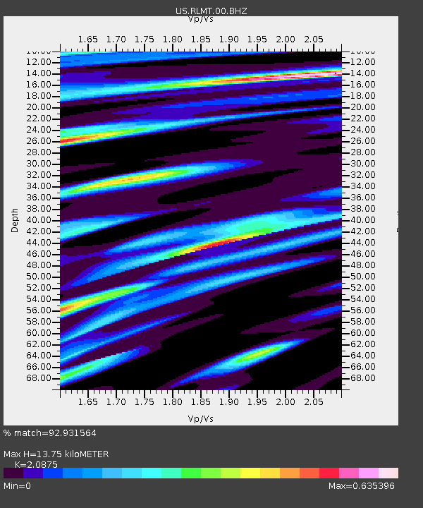
| Estimated Moho Depth: |
13.75 km |
| Estimated Crust Vp/Vs: |
2.09 |
| Assumed Crust Vp: |
6.242 km/s |
| Estimated Crust Vs: |
2.99 km/s |
| Estimated Crust Poisson's Ratio: |
0.35 |
|
| Radial Match: |
92.931564 % |
| Radial Bump: |
388 |
| Transverse Match: |
86.87225 % |
| Transverse Bump: |
400 |
| SOD ConfigId: |
3131071 |
| Insert Time: |
2018-11-23 02:02:54.824 +0000 |
| GWidth: |
2.5 |
| Max Bumps: |
400 |
| Tol: |
0.001 |
|

Signal To Noise
| Channel | StoN | STA | LTA |
| US:RLMT:00:BHZ:20181109T01:58:06.048999Z | 5.274082 | 1.194744E-6 | 2.2653117E-7 |
| US:RLMT:00:BH1:20181109T01:58:06.048999Z | 3.5728312 | 7.975088E-7 | 2.232148E-7 |
| US:RLMT:00:BH2:20181109T01:58:06.048999Z | 1.6901156 | 3.4708603E-7 | 2.0536231E-7 |
| Arrivals |
| Ps | 2.5 SECOND |
| PpPs | 6.5 SECOND |
| PsPs/PpSs | 9.0 SECOND |


