You are here: Home > Network List > CC - Cascade Chain Volcano Monitoring Stations List
> Station PR05 Puyallup River 05 > Earthquake Result Viewer
PR05 Puyallup River 05 - Earthquake Result Viewer
| Earthquake location: |
Northwest Of Kuril Islands |
| Earthquake latitude/longitude: |
48.0/147.4 |
| Earthquake time(UTC): |
2023/06/17 (168) 11:36:00 GMT |
| Earthquake Depth: |
418 km |
| Earthquake Magnitude: |
5.7 mww |
| Earthquake Catalog/Contributor: |
NEIC PDE/us |
|
| Network: |
CC Cascade Chain Volcano Monitoring |
| Station: |
PR05 Puyallup River 05 |
| Lat/Lon: |
46.84 N/121.95 W |
| Elevation: |
1553 m |
|
| Distance: |
57.8 deg |
| Az: |
54.208 deg |
| Baz: |
307.412 deg |
| Ray Param: |
0.06169176 |
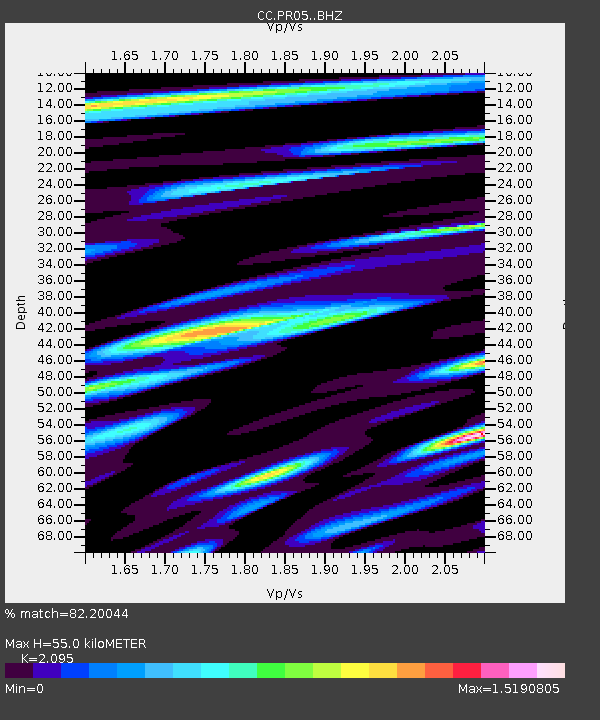
| Estimated Moho Depth: |
55.0 km |
| Estimated Crust Vp/Vs: |
2.10 |
| Assumed Crust Vp: |
6.597 km/s |
| Estimated Crust Vs: |
3.149 km/s |
| Estimated Crust Poisson's Ratio: |
0.35 |
|
| Radial Match: |
82.20044 % |
| Radial Bump: |
400 |
| Transverse Match: |
82.15813 % |
| Transverse Bump: |
400 |
| SOD ConfigId: |
30536071 |
| Insert Time: |
2023-07-01 11:57:02.175 +0000 |
| GWidth: |
2.5 |
| Max Bumps: |
400 |
| Tol: |
0.001 |
|

Signal To Noise
| Channel | StoN | STA | LTA |
| CC:PR05: :BHZ:20230617T11:44:39.799979Z | 7.608256 | 1.1870706E-6 | 1.56024E-7 |
| CC:PR05: :BHN:20230617T11:44:39.799979Z | 3.3949428 | 4.259319E-7 | 1.254607E-7 |
| CC:PR05: :BHE:20230617T11:44:39.799979Z | 3.9793556 | 5.657757E-7 | 1.4217771E-7 |
| Arrivals |
| Ps | 9.5 SECOND |
| PpPs | 25 SECOND |
| PsPs/PpSs | 34 SECOND |


