You are here: Home > Network List > CI - Caltech Regional Seismic Network Stations List
> Station BFS Mt Baldy Forest Station > Earthquake Result Viewer
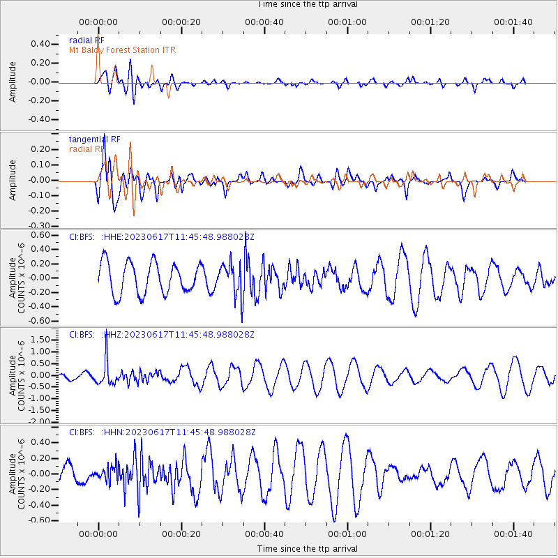
BFS Mt Baldy Forest Station - Earthquake Result Viewer
*The percent match for this event was below the threshold and hence no stack was calculated.
| Earthquake location: |
Northwest Of Kuril Islands |
| Earthquake latitude/longitude: |
48.0/147.4 |
| Earthquake time(UTC): |
2023/06/17 (168) 11:36:00 GMT |
| Earthquake Depth: |
418 km |
| Earthquake Magnitude: |
5.7 mww |
| Earthquake Catalog/Contributor: |
NEIC PDE/us |
|
| Network: |
CI Caltech Regional Seismic Network |
| Station: |
BFS Mt Baldy Forest Station |
| Lat/Lon: |
34.24 N/117.66 W |
| Elevation: |
1312 m |
|
| Distance: |
68.5 deg |
| Az: |
62.496 deg |
| Baz: |
313.972 deg |
| Ray Param: |
$rayparam |
*The percent match for this event was below the threshold and hence was not used in the summary stack. |
|
| Radial Match: |
39.560528 % |
| Radial Bump: |
400 |
| Transverse Match: |
78.95295 % |
| Transverse Bump: |
400 |
| SOD ConfigId: |
30536071 |
| Insert Time: |
2023-07-01 11:57:47.733 +0000 |
| GWidth: |
2.5 |
| Max Bumps: |
400 |
| Tol: |
0.001 |
|
Signal To Noise
| Channel | StoN | STA | LTA |
| CI:BFS: :HHZ:20230617T11:45:48.988028Z | 5.1927457 | 5.250223E-7 | 1.0110688E-7 |
| CI:BFS: :HHN:20230617T11:45:48.988028Z | 1.0816362 | 9.043751E-8 | 8.361176E-8 |
| CI:BFS: :HHE:20230617T11:45:48.988028Z | 1.0952276 | 2.3452948E-7 | 2.1413766E-7 |
| Arrivals |
| Ps | |
| PpPs | |
| PsPs/PpSs | |


