You are here: Home > Network List > CI - Caltech Regional Seismic Network Stations List
> Station SMM Simmler, CA, USA > Earthquake Result Viewer
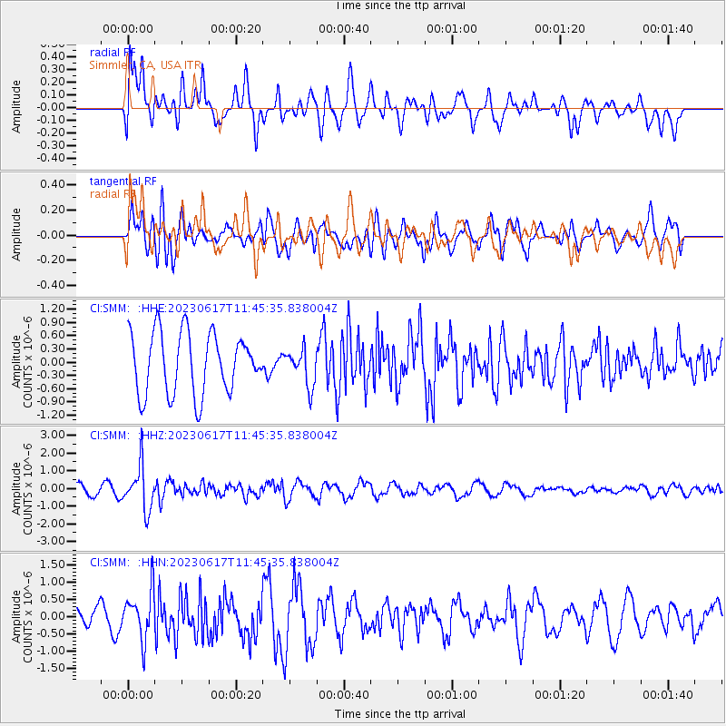
SMM Simmler, CA, USA - Earthquake Result Viewer
*The percent match for this event was below the threshold and hence no stack was calculated.
| Earthquake location: |
Northwest Of Kuril Islands |
| Earthquake latitude/longitude: |
48.0/147.4 |
| Earthquake time(UTC): |
2023/06/17 (168) 11:36:00 GMT |
| Earthquake Depth: |
418 km |
| Earthquake Magnitude: |
5.7 mww |
| Earthquake Catalog/Contributor: |
NEIC PDE/us |
|
| Network: |
CI Caltech Regional Seismic Network |
| Station: |
SMM Simmler, CA, USA |
| Lat/Lon: |
35.31 N/120.00 W |
| Elevation: |
599 m |
|
| Distance: |
66.4 deg |
| Az: |
63.084 deg |
| Baz: |
312.87 deg |
| Ray Param: |
$rayparam |
*The percent match for this event was below the threshold and hence was not used in the summary stack. |
|
| Radial Match: |
48.474857 % |
| Radial Bump: |
400 |
| Transverse Match: |
53.16896 % |
| Transverse Bump: |
400 |
| SOD ConfigId: |
30536071 |
| Insert Time: |
2023-07-01 11:59:16.389 +0000 |
| GWidth: |
2.5 |
| Max Bumps: |
400 |
| Tol: |
0.001 |
|
Signal To Noise
| Channel | StoN | STA | LTA |
| CI:SMM: :HHZ:20230617T11:45:35.838004Z | 3.1982112 | 1.2553212E-6 | 3.925073E-7 |
| CI:SMM: :HHN:20230617T11:45:35.838004Z | 2.638659 | 7.1144166E-7 | 2.6962243E-7 |
| CI:SMM: :HHE:20230617T11:45:35.838004Z | 0.6086641 | 4.197163E-7 | 6.895696E-7 |
| Arrivals |
| Ps | |
| PpPs | |
| PsPs/PpSs | |


