You are here: Home > Network List > CI - Caltech Regional Seismic Network Stations List
> Station SWS Sam W. Stewart, Westmorland, CA, USA > Earthquake Result Viewer
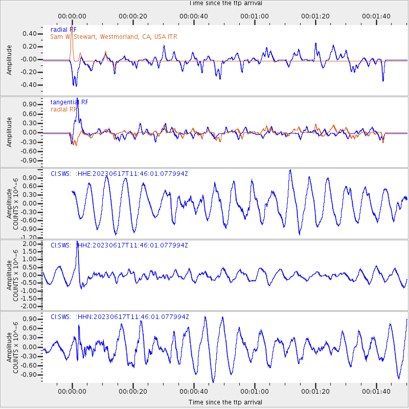
SWS Sam W. Stewart, Westmorland, CA, USA - Earthquake Result Viewer
*The percent match for this event was below the threshold and hence no stack was calculated.
| Earthquake location: |
Northwest Of Kuril Islands |
| Earthquake latitude/longitude: |
48.0/147.4 |
| Earthquake time(UTC): |
2023/06/17 (168) 11:36:00 GMT |
| Earthquake Depth: |
418 km |
| Earthquake Magnitude: |
5.7 mww |
| Earthquake Catalog/Contributor: |
NEIC PDE/us |
|
| Network: |
CI Caltech Regional Seismic Network |
| Station: |
SWS Sam W. Stewart, Westmorland, CA, USA |
| Lat/Lon: |
32.94 N/115.80 W |
| Elevation: |
140 m |
|
| Distance: |
70.5 deg |
| Az: |
62.32 deg |
| Baz: |
314.936 deg |
| Ray Param: |
$rayparam |
*The percent match for this event was below the threshold and hence was not used in the summary stack. |
|
| Radial Match: |
63.148537 % |
| Radial Bump: |
400 |
| Transverse Match: |
70.764626 % |
| Transverse Bump: |
377 |
| SOD ConfigId: |
30536071 |
| Insert Time: |
2023-07-01 11:59:23.232 +0000 |
| GWidth: |
2.5 |
| Max Bumps: |
400 |
| Tol: |
0.001 |
|
Signal To Noise
| Channel | StoN | STA | LTA |
| CI:SWS: :HHZ:20230617T11:46:01.077994Z | 3.3644662 | 8.286697E-7 | 2.463005E-7 |
| CI:SWS: :HHN:20230617T11:46:01.077994Z | 1.2511274 | 2.6027718E-7 | 2.0803414E-7 |
| CI:SWS: :HHE:20230617T11:46:01.077994Z | 0.64883107 | 3.8677427E-7 | 5.961093E-7 |
| Arrivals |
| Ps | |
| PpPs | |
| PsPs/PpSs | |


