You are here: Home > Network List > CI - Caltech Regional Seismic Network Stations List
> Station VES Vestal, Richgrove, CA, USA > Earthquake Result Viewer
VES Vestal, Richgrove, CA, USA - Earthquake Result Viewer
| Earthquake location: |
Northwest Of Kuril Islands |
| Earthquake latitude/longitude: |
48.0/147.4 |
| Earthquake time(UTC): |
2023/06/17 (168) 11:36:00 GMT |
| Earthquake Depth: |
418 km |
| Earthquake Magnitude: |
5.7 mww |
| Earthquake Catalog/Contributor: |
NEIC PDE/us |
|
| Network: |
CI Caltech Regional Seismic Network |
| Station: |
VES Vestal, Richgrove, CA, USA |
| Lat/Lon: |
35.84 N/119.08 W |
| Elevation: |
154 m |
|
| Distance: |
66.6 deg |
| Az: |
62.113 deg |
| Baz: |
313.01 deg |
| Ray Param: |
0.056160286 |
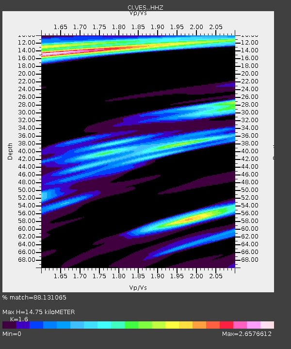
| Estimated Moho Depth: |
14.75 km |
| Estimated Crust Vp/Vs: |
1.60 |
| Assumed Crust Vp: |
6.1 km/s |
| Estimated Crust Vs: |
3.812 km/s |
| Estimated Crust Poisson's Ratio: |
0.18 |
|
| Radial Match: |
88.131065 % |
| Radial Bump: |
388 |
| Transverse Match: |
79.709785 % |
| Transverse Bump: |
396 |
| SOD ConfigId: |
30536071 |
| Insert Time: |
2023-07-01 11:59:32.431 +0000 |
| GWidth: |
2.5 |
| Max Bumps: |
400 |
| Tol: |
0.001 |
|

Signal To Noise
| Channel | StoN | STA | LTA |
| CI:VES: :HHZ:20230617T11:45:36.997977Z | 4.774883 | 1.1835502E-6 | 2.4787E-7 |
| CI:VES: :HHN:20230617T11:45:36.997977Z | 0.7596535 | 3.4501085E-7 | 4.5416868E-7 |
| CI:VES: :HHE:20230617T11:45:36.997977Z | 1.6600832 | 1.2654904E-6 | 7.6230543E-7 |
| Arrivals |
| Ps | 1.5 SECOND |
| PpPs | 6.1 SECOND |
| PsPs/PpSs | 7.6 SECOND |


