You are here: Home > Network List > TA - USArray Transportable Network (new EarthScope stations) Stations List
> Station G20A Bridger, MT, USA > Earthquake Result Viewer
G20A Bridger, MT, USA - Earthquake Result Viewer
| Earthquake location: |
Northern Peru |
| Earthquake latitude/longitude: |
-5.1/-77.5 |
| Earthquake time(UTC): |
2010/05/19 (139) 04:15:44 GMT |
| Earthquake Depth: |
140 km |
| Earthquake Magnitude: |
6.0 MB, 6.0 MW, 6.0 MW |
| Earthquake Catalog/Contributor: |
WHDF/NEIC |
|
| Network: |
TA USArray Transportable Network (new EarthScope stations) |
| Station: |
G20A Bridger, MT, USA |
| Lat/Lon: |
45.22 N/108.21 W |
| Elevation: |
1431 m |
|
| Distance: |
57.1 deg |
| Az: |
334.562 deg |
| Baz: |
142.742 deg |
| Ray Param: |
0.06328364 |
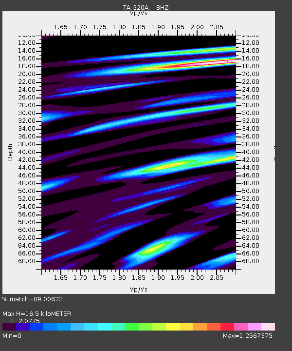
| Estimated Moho Depth: |
16.5 km |
| Estimated Crust Vp/Vs: |
2.08 |
| Assumed Crust Vp: |
6.242 km/s |
| Estimated Crust Vs: |
3.005 km/s |
| Estimated Crust Poisson's Ratio: |
0.35 |
|
| Radial Match: |
89.00623 % |
| Radial Bump: |
400 |
| Transverse Match: |
65.117836 % |
| Transverse Bump: |
400 |
| SOD ConfigId: |
314592 |
| Insert Time: |
2010-09-04 07:25:47.906 +0000 |
| GWidth: |
2.5 |
| Max Bumps: |
400 |
| Tol: |
0.001 |
|

Signal To Noise
| Channel | StoN | STA | LTA |
| TA:G20A: :BHZ:20100519T04:24:45.09998Z | 10.228166 | 1.413439E-6 | 1.3819086E-7 |
| TA:G20A: :BHN:20100519T04:24:45.09998Z | 8.467521 | 7.195803E-7 | 8.498123E-8 |
| TA:G20A: :BHE:20100519T04:24:45.09998Z | 6.8408823 | 5.031695E-7 | 7.35533E-8 |
| Arrivals |
| Ps | 3.0 SECOND |
| PpPs | 7.8 SECOND |
| PsPs/PpSs | 11 SECOND |


