You are here: Home > Network List > CN - Canadian National Seismograph Network Stations List
> Station INK INUVIK, NT > Earthquake Result Viewer
INK INUVIK, NT - Earthquake Result Viewer
*The percent match for this event was below the threshold and hence no stack was calculated.
| Earthquake location: |
Northwest Of Kuril Islands |
| Earthquake latitude/longitude: |
48.0/147.4 |
| Earthquake time(UTC): |
2023/06/17 (168) 11:36:00 GMT |
| Earthquake Depth: |
418 km |
| Earthquake Magnitude: |
5.7 mww |
| Earthquake Catalog/Contributor: |
NEIC PDE/us |
|
| Network: |
CN Canadian National Seismograph Network |
| Station: |
INK INUVIK, NT |
| Lat/Lon: |
68.31 N/133.53 W |
| Elevation: |
44 m |
|
| Distance: |
42.7 deg |
| Az: |
32.548 deg |
| Baz: |
283.412 deg |
| Ray Param: |
$rayparam |
*The percent match for this event was below the threshold and hence was not used in the summary stack. |
|
| Radial Match: |
45.01796 % |
| Radial Bump: |
400 |
| Transverse Match: |
52.43382 % |
| Transverse Bump: |
400 |
| SOD ConfigId: |
30536071 |
| Insert Time: |
2023-07-01 12:00:58.538 +0000 |
| GWidth: |
2.5 |
| Max Bumps: |
400 |
| Tol: |
0.001 |
|
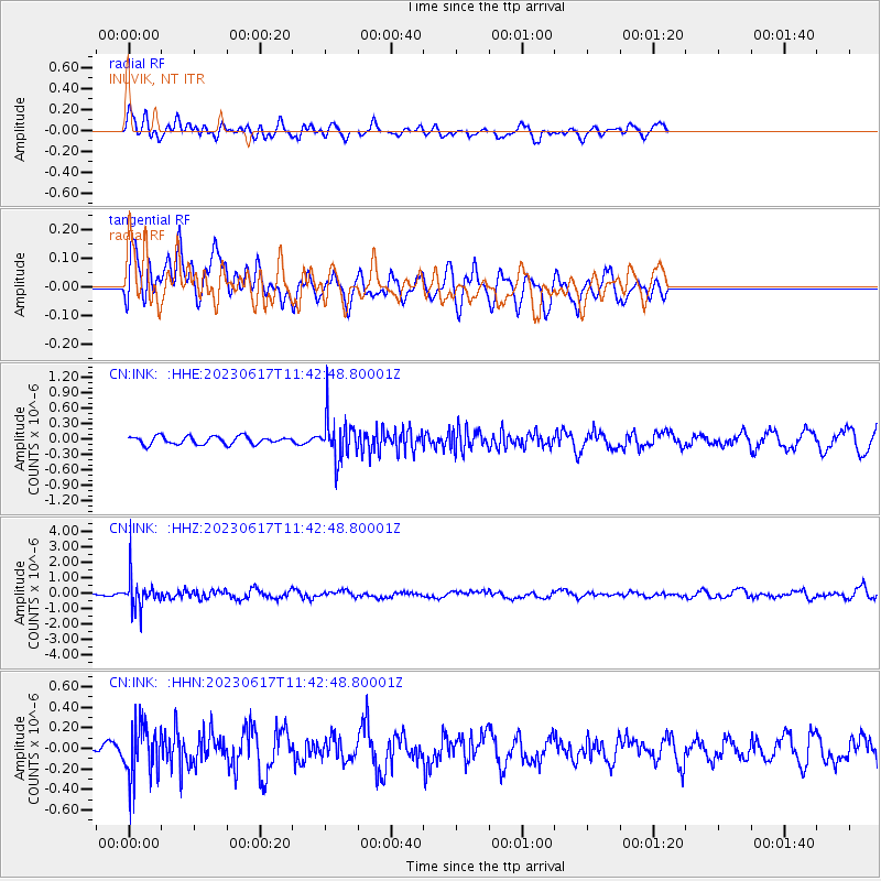
Signal To Noise
| Channel | StoN | STA | LTA |
| CN:INK: :HHZ:20230617T11:42:48.80001Z | 5.7772536 | 1.0148088E-6 | 1.7565591E-7 |
| CN:INK: :HHN:20230617T11:42:48.80001Z | 2.7396865 | 2.583034E-7 | 9.42821E-8 |
| CN:INK: :HHE:20230617T11:42:48.80001Z | 5.2005467 | 3.96189E-7 | 7.618218E-8 |
| Arrivals |
| Ps | |
| PpPs | |
| PsPs/PpSs | |


