You are here: Home > Network List > CN - Canadian National Seismograph Network Stations List
> Station ULM LAC DU BONNET, MB > Earthquake Result Viewer
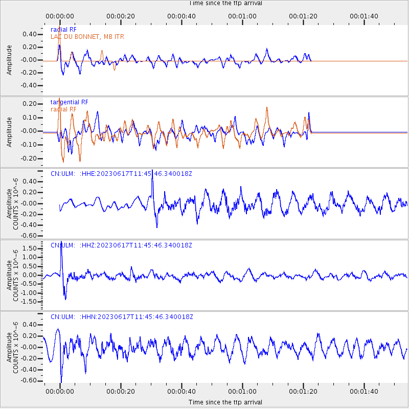
ULM LAC DU BONNET, MB - Earthquake Result Viewer
*The percent match for this event was below the threshold and hence no stack was calculated.
| Earthquake location: |
Northwest Of Kuril Islands |
| Earthquake latitude/longitude: |
48.0/147.4 |
| Earthquake time(UTC): |
2023/06/17 (168) 11:36:00 GMT |
| Earthquake Depth: |
418 km |
| Earthquake Magnitude: |
5.7 mww |
| Earthquake Catalog/Contributor: |
NEIC PDE/us |
|
| Network: |
CN Canadian National Seismograph Network |
| Station: |
ULM LAC DU BONNET, MB |
| Lat/Lon: |
50.25 N/95.88 W |
| Elevation: |
251 m |
|
| Distance: |
68.1 deg |
| Az: |
38.161 deg |
| Baz: |
319.687 deg |
| Ray Param: |
$rayparam |
*The percent match for this event was below the threshold and hence was not used in the summary stack. |
|
| Radial Match: |
67.47695 % |
| Radial Bump: |
388 |
| Transverse Match: |
33.838886 % |
| Transverse Bump: |
333 |
| SOD ConfigId: |
30536071 |
| Insert Time: |
2023-07-01 12:01:56.681 +0000 |
| GWidth: |
2.5 |
| Max Bumps: |
400 |
| Tol: |
0.001 |
|
Signal To Noise
| Channel | StoN | STA | LTA |
| CN:ULM: :HHZ:20230617T11:45:46.340018Z | 5.4859443 | 6.7821827E-7 | 1.2362835E-7 |
| CN:ULM: :HHN:20230617T11:45:46.340018Z | 2.8623319 | 2.3566099E-7 | 8.233182E-8 |
| CN:ULM: :HHE:20230617T11:45:46.340018Z | 3.7341824 | 2.2301543E-7 | 5.9722694E-8 |
| Arrivals |
| Ps | |
| PpPs | |
| PsPs/PpSs | |


