You are here: Home > Network List > GM - US Geological Survey Networks Stations List
> Station IWM01 Jericho 2M Well Monitoring Station > Earthquake Result Viewer
IWM01 Jericho 2M Well Monitoring Station - Earthquake Result Viewer
*The percent match for this event was below the threshold and hence no stack was calculated.
| Earthquake location: |
Northwest Of Kuril Islands |
| Earthquake latitude/longitude: |
48.0/147.4 |
| Earthquake time(UTC): |
2023/06/17 (168) 11:36:00 GMT |
| Earthquake Depth: |
418 km |
| Earthquake Magnitude: |
5.7 mww |
| Earthquake Catalog/Contributor: |
NEIC PDE/us |
|
| Network: |
GM US Geological Survey Networks |
| Station: |
IWM01 Jericho 2M Well Monitoring Station |
| Lat/Lon: |
36.73 N/96.53 W |
| Elevation: |
328 m |
|
| Distance: |
78.3 deg |
| Az: |
47.461 deg |
| Baz: |
321.941 deg |
| Ray Param: |
$rayparam |
*The percent match for this event was below the threshold and hence was not used in the summary stack. |
|
| Radial Match: |
48.93012 % |
| Radial Bump: |
400 |
| Transverse Match: |
42.71251 % |
| Transverse Bump: |
400 |
| SOD ConfigId: |
30536071 |
| Insert Time: |
2023-07-01 12:03:46.605 +0000 |
| GWidth: |
2.5 |
| Max Bumps: |
400 |
| Tol: |
0.001 |
|
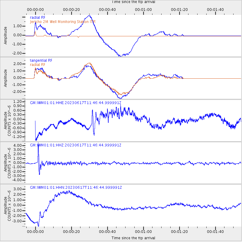
Signal To Noise
| Channel | StoN | STA | LTA |
| GM:IWM01:01:HHZ:20230617T11:46:44.999991Z | 13.638451 | 1.3195564E-6 | 9.6752665E-8 |
| GM:IWM01:01:HHN:20230617T11:46:44.999991Z | 1.0625625 | 1.6249061E-6 | 1.5292335E-6 |
| GM:IWM01:01:HHE:20230617T11:46:44.999991Z | 1.3226525 | 4.768474E-7 | 3.605236E-7 |
| Arrivals |
| Ps | |
| PpPs | |
| PsPs/PpSs | |


