You are here: Home > Network List > TA - USArray Transportable Network (new EarthScope stations) Stations List
> Station J24A Dixon Ranch, Lance Creek, WY, USA > Earthquake Result Viewer
J24A Dixon Ranch, Lance Creek, WY, USA - Earthquake Result Viewer
| Earthquake location: |
Northern Peru |
| Earthquake latitude/longitude: |
-5.1/-77.5 |
| Earthquake time(UTC): |
2010/05/19 (139) 04:15:44 GMT |
| Earthquake Depth: |
140 km |
| Earthquake Magnitude: |
6.0 MB, 6.0 MW, 6.0 MW |
| Earthquake Catalog/Contributor: |
WHDF/NEIC |
|
| Network: |
TA USArray Transportable Network (new EarthScope stations) |
| Station: |
J24A Dixon Ranch, Lance Creek, WY, USA |
| Lat/Lon: |
43.33 N/104.66 W |
| Elevation: |
1315 m |
|
| Distance: |
54.1 deg |
| Az: |
335.739 deg |
| Baz: |
145.88 deg |
| Ray Param: |
0.06523871 |
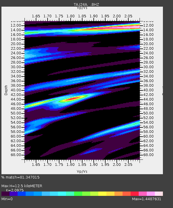
| Estimated Moho Depth: |
12.5 km |
| Estimated Crust Vp/Vs: |
2.10 |
| Assumed Crust Vp: |
6.159 km/s |
| Estimated Crust Vs: |
2.936 km/s |
| Estimated Crust Poisson's Ratio: |
0.35 |
|
| Radial Match: |
81.347015 % |
| Radial Bump: |
400 |
| Transverse Match: |
72.48269 % |
| Transverse Bump: |
400 |
| SOD ConfigId: |
314592 |
| Insert Time: |
2010-09-04 07:28:15.898 +0000 |
| GWidth: |
2.5 |
| Max Bumps: |
400 |
| Tol: |
0.001 |
|
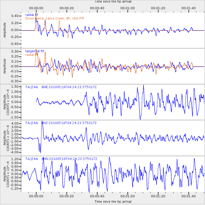
Signal To Noise
| Channel | StoN | STA | LTA |
| TA:J24A: :BHZ:20100519T04:24:23.575017Z | 18.737453 | 2.263753E-6 | 1.2081433E-7 |
| TA:J24A: :BHN:20100519T04:24:23.575017Z | 2.3577676 | 6.588793E-7 | 2.794505E-7 |
| TA:J24A: :BHE:20100519T04:24:23.575017Z | 3.8672767 | 5.1208656E-7 | 1.3241528E-7 |
| Arrivals |
| Ps | 2.3 SECOND |
| PpPs | 6.0 SECOND |
| PsPs/PpSs | 8.4 SECOND |


