You are here: Home > Network List > TA - USArray Transportable Network (new EarthScope stations) Stations List
> Station R23A Moffat, CO, USA > Earthquake Result Viewer
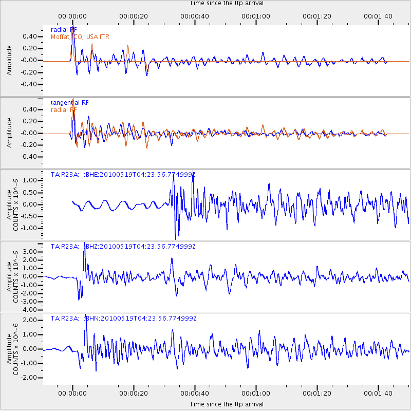
R23A Moffat, CO, USA - Earthquake Result Viewer
*The percent match for this event was below the threshold and hence no stack was calculated.
| Earthquake location: |
Northern Peru |
| Earthquake latitude/longitude: |
-5.1/-77.5 |
| Earthquake time(UTC): |
2010/05/19 (139) 04:15:44 GMT |
| Earthquake Depth: |
140 km |
| Earthquake Magnitude: |
6.0 MB, 6.0 MW, 6.0 MW |
| Earthquake Catalog/Contributor: |
WHDF/NEIC |
|
| Network: |
TA USArray Transportable Network (new EarthScope stations) |
| Station: |
R23A Moffat, CO, USA |
| Lat/Lon: |
38.19 N/105.83 W |
| Elevation: |
2547 m |
|
| Distance: |
50.4 deg |
| Az: |
331.02 deg |
| Baz: |
142.23 deg |
| Ray Param: |
$rayparam |
*The percent match for this event was below the threshold and hence was not used in the summary stack. |
|
| Radial Match: |
86.81146 % |
| Radial Bump: |
400 |
| Transverse Match: |
86.396965 % |
| Transverse Bump: |
400 |
| SOD ConfigId: |
314592 |
| Insert Time: |
2010-09-04 07:28:28.307 +0000 |
| GWidth: |
2.5 |
| Max Bumps: |
400 |
| Tol: |
0.001 |
|
Signal To Noise
| Channel | StoN | STA | LTA |
| TA:R23A: :BHZ:20100519T04:23:56.774999Z | 15.283718 | 1.5367651E-6 | 1.00549165E-7 |
| TA:R23A: :BHN:20100519T04:23:56.774999Z | 11.928784 | 8.4171666E-7 | 7.056182E-8 |
| TA:R23A: :BHE:20100519T04:23:56.774999Z | 4.518205 | 5.565744E-7 | 1.2318485E-7 |
| Arrivals |
| Ps | |
| PpPs | |
| PsPs/PpSs | |


