You are here: Home > Network List > TA - USArray Transportable Network (new EarthScope stations) Stations List
> Station E24A Baker, MT, USA > Earthquake Result Viewer
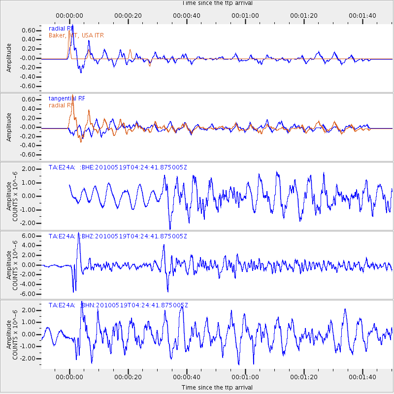
E24A Baker, MT, USA - Earthquake Result Viewer

| Earthquake location: |
Northern Peru |
| Earthquake latitude/longitude: |
-5.1/-77.5 |
| Earthquake time(UTC): |
2010/05/19 (139) 04:15:44 GMT |
| Earthquake Depth: |
140 km |
| Earthquake Magnitude: |
6.0 MB, 6.0 MW, 6.0 MW |
| Earthquake Catalog/Contributor: |
WHDF/NEIC |
|
| Network: |
TA USArray Transportable Network (new EarthScope stations) |
| Station: |
E24A Baker, MT, USA |
| Lat/Lon: |
46.56 N/104.31 W |
| Elevation: |
912 m |
|
| Distance: |
56.6 deg |
| Az: |
338.15 deg |
| Baz: |
147.501 deg |
| Ray Param: |
0.0635746 |
| Estimated Moho Depth: |
19.5 km |
| Estimated Crust Vp/Vs: |
1.69 |
| Assumed Crust Vp: |
6.438 km/s |
| Estimated Crust Vs: |
3.82 km/s |
| Estimated Crust Poisson's Ratio: |
0.23 |
|
| Radial Match: |
89.242004 % |
| Radial Bump: |
381 |
| Transverse Match: |
71.52128 % |
| Transverse Bump: |
400 |
| SOD ConfigId: |
314592 |
| Insert Time: |
2010-09-04 07:28:28.892 +0000 |
| GWidth: |
2.5 |
| Max Bumps: |
400 |
| Tol: |
0.001 |
|
Signal To Noise
| Channel | StoN | STA | LTA |
| TA:E24A: :BHZ:20100519T04:24:41.875005Z | 28.488293 | 2.8914837E-6 | 1.01497264E-7 |
| TA:E24A: :BHN:20100519T04:24:41.875005Z | 3.932477 | 1.1246572E-6 | 2.8599206E-7 |
| TA:E24A: :BHE:20100519T04:24:41.875005Z | 1.9350743 | 9.840637E-7 | 5.0854055E-7 |
| Arrivals |
| Ps | 2.2 SECOND |
| PpPs | 7.7 SECOND |
| PsPs/PpSs | 9.9 SECOND |


