You are here: Home > Network List > TA - USArray Transportable Network (new EarthScope stations) Stations List
> Station M25A Palm-Egli Farm, Albin, WY, USA > Earthquake Result Viewer
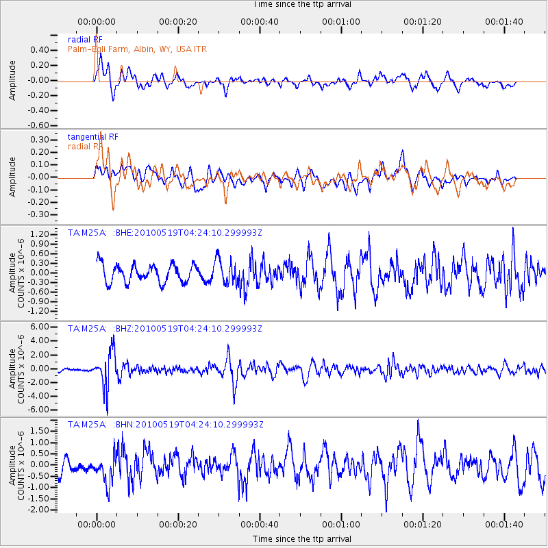
M25A Palm-Egli Farm, Albin, WY, USA - Earthquake Result Viewer
*The percent match for this event was below the threshold and hence no stack was calculated.
| Earthquake location: |
Northern Peru |
| Earthquake latitude/longitude: |
-5.1/-77.5 |
| Earthquake time(UTC): |
2010/05/19 (139) 04:15:44 GMT |
| Earthquake Depth: |
140 km |
| Earthquake Magnitude: |
6.0 MB, 6.0 MW, 6.0 MW |
| Earthquake Catalog/Contributor: |
WHDF/NEIC |
|
| Network: |
TA USArray Transportable Network (new EarthScope stations) |
| Station: |
M25A Palm-Egli Farm, Albin, WY, USA |
| Lat/Lon: |
41.43 N/104.06 W |
| Elevation: |
1636 m |
|
| Distance: |
52.2 deg |
| Az: |
334.873 deg |
| Baz: |
145.768 deg |
| Ray Param: |
$rayparam |
*The percent match for this event was below the threshold and hence was not used in the summary stack. |
|
| Radial Match: |
79.0089 % |
| Radial Bump: |
400 |
| Transverse Match: |
68.521965 % |
| Transverse Bump: |
400 |
| SOD ConfigId: |
314592 |
| Insert Time: |
2010-09-04 07:28:40.533 +0000 |
| GWidth: |
2.5 |
| Max Bumps: |
400 |
| Tol: |
0.001 |
|
Signal To Noise
| Channel | StoN | STA | LTA |
| TA:M25A: :BHZ:20100519T04:24:10.299993Z | 17.109594 | 2.619217E-6 | 1.5308467E-7 |
| TA:M25A: :BHN:20100519T04:24:10.299993Z | 2.2770352 | 6.4893413E-7 | 2.8499082E-7 |
| TA:M25A: :BHE:20100519T04:24:10.299993Z | 1.3508592 | 3.685036E-7 | 2.7279202E-7 |
| Arrivals |
| Ps | |
| PpPs | |
| PsPs/PpSs | |


