You are here: Home > Network List > UU - University of Utah Regional Network Stations List
> Station SVWY Solvay Mine, WY, USA > Earthquake Result Viewer
SVWY Solvay Mine, WY, USA - Earthquake Result Viewer
| Earthquake location: |
Jan Mayen Island Region |
| Earthquake latitude/longitude: |
71.6/-11.2 |
| Earthquake time(UTC): |
2018/11/09 (313) 01:49:40 GMT |
| Earthquake Depth: |
10 km |
| Earthquake Magnitude: |
6.8 Mww |
| Earthquake Catalog/Contributor: |
NEIC PDE/us |
|
| Network: |
UU University of Utah Regional Network |
| Station: |
SVWY Solvay Mine, WY, USA |
| Lat/Lon: |
41.45 N/109.86 W |
| Elevation: |
1950 m |
|
| Distance: |
53.9 deg |
| Az: |
293.039 deg |
| Baz: |
22.848 deg |
| Ray Param: |
0.06581222 |
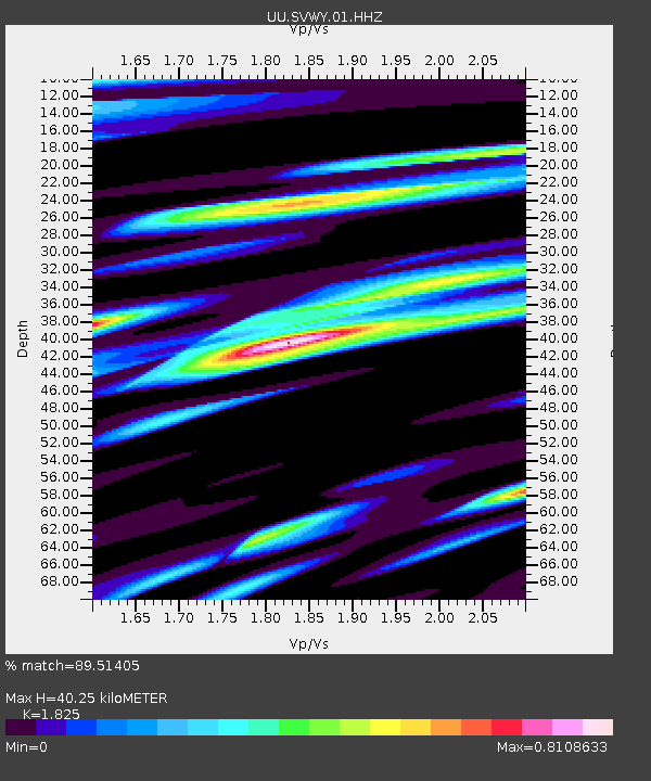
| Estimated Moho Depth: |
40.25 km |
| Estimated Crust Vp/Vs: |
1.83 |
| Assumed Crust Vp: |
6.207 km/s |
| Estimated Crust Vs: |
3.401 km/s |
| Estimated Crust Poisson's Ratio: |
0.29 |
|
| Radial Match: |
89.51405 % |
| Radial Bump: |
400 |
| Transverse Match: |
82.43133 % |
| Transverse Bump: |
400 |
| SOD ConfigId: |
3131071 |
| Insert Time: |
2018-11-23 02:03:56.087 +0000 |
| GWidth: |
2.5 |
| Max Bumps: |
400 |
| Tol: |
0.001 |
|

Signal To Noise
| Channel | StoN | STA | LTA |
| UU:SVWY:01:HHZ:20181109T01:58:32.338977Z | 7.868218 | 2.977548E-8 | 3.7842725E-9 |
| UU:SVWY:01:HHN:20181109T01:58:32.338977Z | 1.7691634 | 1.4417893E-8 | 8.149554E-9 |
| UU:SVWY:01:HHE:20181109T01:58:32.338977Z | 1.9031063 | 1.4364696E-8 | 7.548025E-9 |
| Arrivals |
| Ps | 5.6 SECOND |
| PpPs | 17 SECOND |
| PsPs/PpSs | 23 SECOND |


