You are here: Home > Network List > NE - New England Seismic Network Stations List
> Station EMMW Machias, ME, USA > Earthquake Result Viewer
EMMW Machias, ME, USA - Earthquake Result Viewer
*The percent match for this event was below the threshold and hence no stack was calculated.
| Earthquake location: |
Northwest Of Kuril Islands |
| Earthquake latitude/longitude: |
48.0/147.4 |
| Earthquake time(UTC): |
2023/06/17 (168) 11:36:00 GMT |
| Earthquake Depth: |
418 km |
| Earthquake Magnitude: |
5.7 mww |
| Earthquake Catalog/Contributor: |
NEIC PDE/us |
|
| Network: |
NE New England Seismic Network |
| Station: |
EMMW Machias, ME, USA |
| Lat/Lon: |
44.71 N/67.46 W |
| Elevation: |
35 m |
|
| Distance: |
82.8 deg |
| Az: |
24.23 deg |
| Baz: |
337.24 deg |
| Ray Param: |
$rayparam |
*The percent match for this event was below the threshold and hence was not used in the summary stack. |
|
| Radial Match: |
61.499073 % |
| Radial Bump: |
400 |
| Transverse Match: |
54.99121 % |
| Transverse Bump: |
400 |
| SOD ConfigId: |
30536071 |
| Insert Time: |
2023-07-01 12:11:26.841 +0000 |
| GWidth: |
2.5 |
| Max Bumps: |
400 |
| Tol: |
0.001 |
|
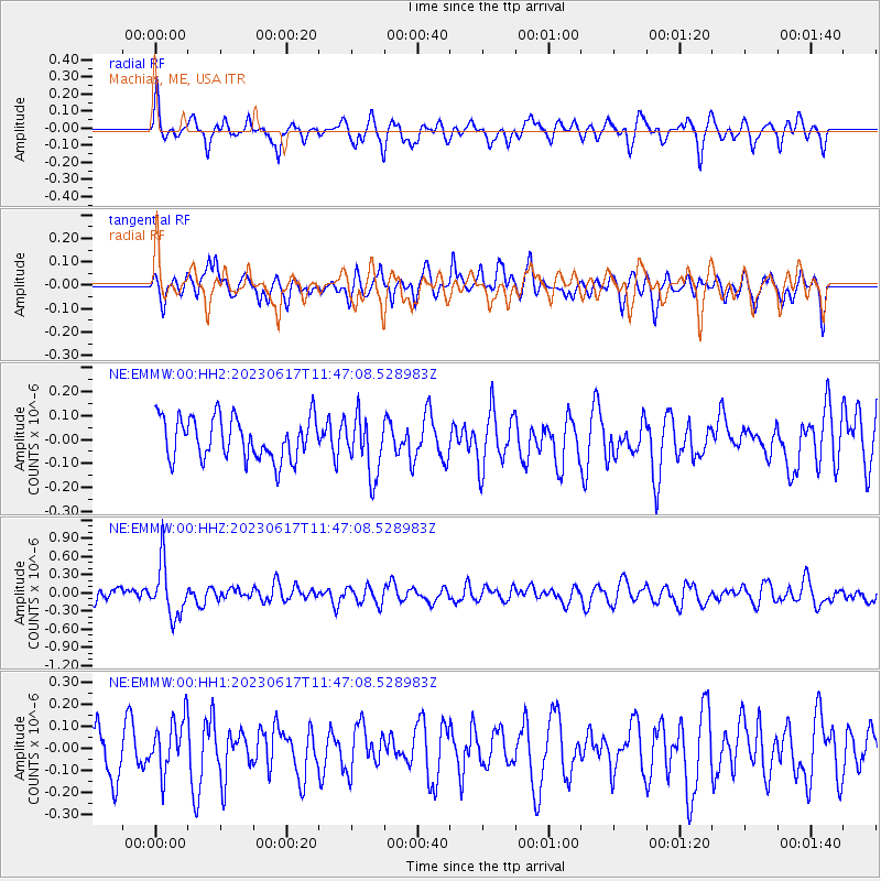
Signal To Noise
| Channel | StoN | STA | LTA |
| NE:EMMW:00:HHZ:20230617T11:47:08.528983Z | 3.9222782 | 4.3527854E-7 | 1.10975954E-7 |
| NE:EMMW:00:HH1:20230617T11:47:08.528983Z | 0.96015453 | 1.2033404E-7 | 1.2532779E-7 |
| NE:EMMW:00:HH2:20230617T11:47:08.528983Z | 1.3958814 | 1.2186433E-7 | 8.730279E-8 |
| Arrivals |
| Ps | |
| PpPs | |
| PsPs/PpSs | |


