You are here: Home > Network List > UU - University of Utah Regional Network Stations List
> Station WPUT Wasatch Plateau, UT,USA > Earthquake Result Viewer
WPUT Wasatch Plateau, UT,USA - Earthquake Result Viewer
| Earthquake location: |
Jan Mayen Island Region |
| Earthquake latitude/longitude: |
71.6/-11.2 |
| Earthquake time(UTC): |
2018/11/09 (313) 01:49:40 GMT |
| Earthquake Depth: |
10 km |
| Earthquake Magnitude: |
6.8 Mww |
| Earthquake Catalog/Contributor: |
NEIC PDE/us |
|
| Network: |
UU University of Utah Regional Network |
| Station: |
WPUT Wasatch Plateau, UT,USA |
| Lat/Lon: |
39.00 N/111.36 W |
| Elevation: |
2618 m |
|
| Distance: |
56.6 deg |
| Az: |
293.19 deg |
| Baz: |
21.972 deg |
| Ray Param: |
0.064057216 |
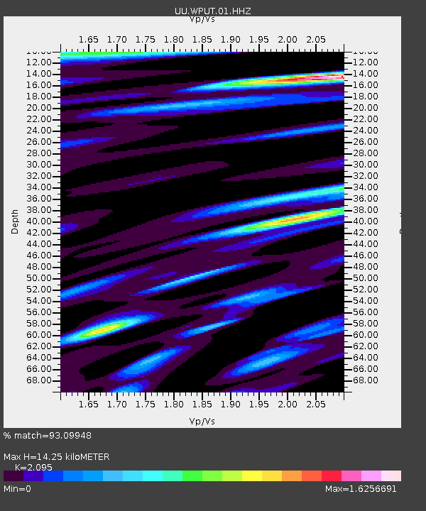
| Estimated Moho Depth: |
14.25 km |
| Estimated Crust Vp/Vs: |
2.10 |
| Assumed Crust Vp: |
6.207 km/s |
| Estimated Crust Vs: |
2.963 km/s |
| Estimated Crust Poisson's Ratio: |
0.35 |
|
| Radial Match: |
93.09948 % |
| Radial Bump: |
400 |
| Transverse Match: |
93.02265 % |
| Transverse Bump: |
400 |
| SOD ConfigId: |
3131071 |
| Insert Time: |
2018-11-23 02:04:06.847 +0000 |
| GWidth: |
2.5 |
| Max Bumps: |
400 |
| Tol: |
0.001 |
|

Signal To Noise
| Channel | StoN | STA | LTA |
| UU:WPUT:01:HHZ:20181109T01:58:51.799976Z | 10.301388 | 4.4465892E-8 | 4.316495E-9 |
| UU:WPUT:01:HHN:20181109T01:58:51.799976Z | 2.8145254 | 1.4588185E-8 | 5.183178E-9 |
| UU:WPUT:01:HHE:20181109T01:58:51.799976Z | 1.8432405 | 7.2849202E-9 | 3.9522354E-9 |
| Arrivals |
| Ps | 2.6 SECOND |
| PpPs | 6.8 SECOND |
| PsPs/PpSs | 9.4 SECOND |


