You are here: Home > Network List > TA - USArray Transportable Network (new EarthScope stations) Stations List
> Station N26A Koester Ranch, Padroni, CO, USA > Earthquake Result Viewer
N26A Koester Ranch, Padroni, CO, USA - Earthquake Result Viewer

| Earthquake location: |
Northern Peru |
| Earthquake latitude/longitude: |
-5.1/-77.5 |
| Earthquake time(UTC): |
2010/05/19 (139) 04:15:44 GMT |
| Earthquake Depth: |
140 km |
| Earthquake Magnitude: |
6.0 MB, 6.0 MW, 6.0 MW |
| Earthquake Catalog/Contributor: |
WHDF/NEIC |
|
| Network: |
TA USArray Transportable Network (new EarthScope stations) |
| Station: |
N26A Koester Ranch, Padroni, CO, USA |
| Lat/Lon: |
40.83 N/103.22 W |
| Elevation: |
1284 m |
|
| Distance: |
51.4 deg |
| Az: |
335.108 deg |
| Baz: |
146.46 deg |
| Ray Param: |
0.06696217 |
| Estimated Moho Depth: |
22.5 km |
| Estimated Crust Vp/Vs: |
1.60 |
| Assumed Crust Vp: |
6.483 km/s |
| Estimated Crust Vs: |
4.052 km/s |
| Estimated Crust Poisson's Ratio: |
0.18 |
|
| Radial Match: |
89.24736 % |
| Radial Bump: |
400 |
| Transverse Match: |
67.44868 % |
| Transverse Bump: |
400 |
| SOD ConfigId: |
314592 |
| Insert Time: |
2010-09-04 07:30:07.834 +0000 |
| GWidth: |
2.5 |
| Max Bumps: |
400 |
| Tol: |
0.001 |
|
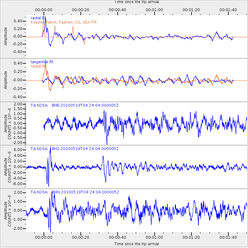
Signal To Noise
| Channel | StoN | STA | LTA |
| TA:N26A: :BHZ:20100519T04:24:04.000005Z | 13.485554 | 2.9991197E-6 | 2.22395E-7 |
| TA:N26A: :BHN:20100519T04:24:04.000005Z | 3.4304357 | 9.666928E-7 | 2.8179886E-7 |
| TA:N26A: :BHE:20100519T04:24:04.000005Z | 2.2721076 | 7.6200087E-7 | 3.3537182E-7 |
| Arrivals |
| Ps | 2.2 SECOND |
| PpPs | 8.5 SECOND |
| PsPs/PpSs | 11 SECOND |


