You are here: Home > Network List > TA - USArray Transportable Network (new EarthScope stations) Stations List
> Station V29A Stinnett, TX, USA > Earthquake Result Viewer
V29A Stinnett, TX, USA - Earthquake Result Viewer
| Earthquake location: |
Northern Peru |
| Earthquake latitude/longitude: |
-5.1/-77.5 |
| Earthquake time(UTC): |
2010/05/19 (139) 04:15:44 GMT |
| Earthquake Depth: |
140 km |
| Earthquake Magnitude: |
6.0 MB, 6.0 MW, 6.0 MW |
| Earthquake Catalog/Contributor: |
WHDF/NEIC |
|
| Network: |
TA USArray Transportable Network (new EarthScope stations) |
| Station: |
V29A Stinnett, TX, USA |
| Lat/Lon: |
35.87 N/101.52 W |
| Elevation: |
953 m |
|
| Distance: |
46.5 deg |
| Az: |
332.943 deg |
| Baz: |
146.088 deg |
| Ray Param: |
0.07007383 |
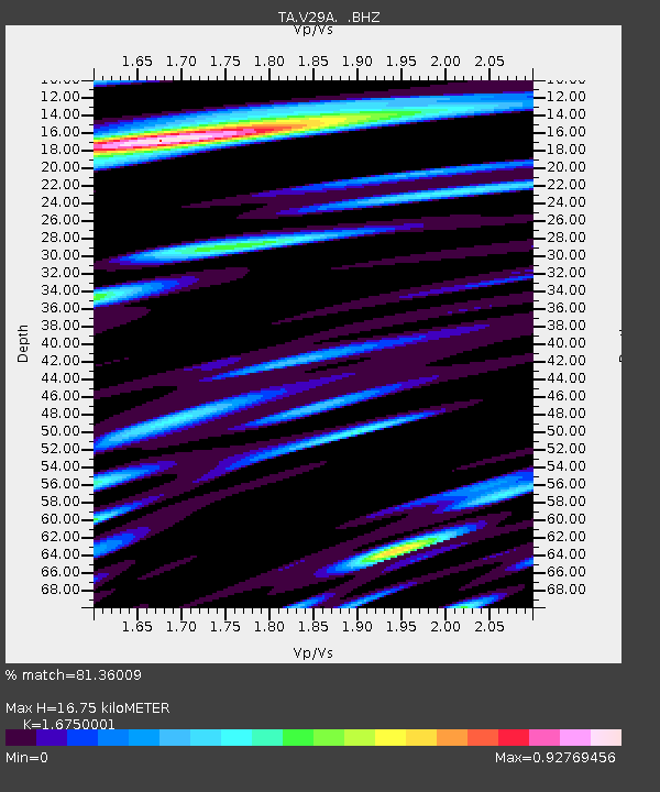
| Estimated Moho Depth: |
16.75 km |
| Estimated Crust Vp/Vs: |
1.68 |
| Assumed Crust Vp: |
6.426 km/s |
| Estimated Crust Vs: |
3.836 km/s |
| Estimated Crust Poisson's Ratio: |
0.22 |
|
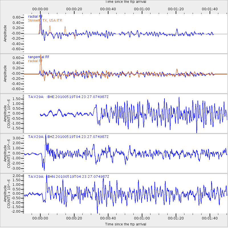
| Radial Match: |
81.36009 % |
| Radial Bump: |
400 |
| Transverse Match: |
65.81419 % |
| Transverse Bump: |
400 |
| SOD ConfigId: |
314592 |
| Insert Time: |
2010-09-04 07:30:44.677 +0000 |
| GWidth: |
2.5 |
| Max Bumps: |
400 |
| Tol: |
0.001 |
|
Signal To Noise
| Channel | StoN | STA | LTA |
| TA:V29A: :BHZ:20100519T04:23:27.074987Z | 15.968631 | 1.622319E-6 | 1.01594125E-7 |
| TA:V29A: :BHN:20100519T04:23:27.074987Z | 4.735438 | 7.239086E-7 | 1.5287047E-7 |
| TA:V29A: :BHE:20100519T04:23:27.074987Z | 3.3141005 | 5.343544E-7 | 1.6123663E-7 |
| Arrivals |
| Ps | 1.9 SECOND |
| PpPs | 6.5 SECOND |
| PsPs/PpSs | 8.4 SECOND |


