You are here: Home > Network List > TA - USArray Transportable Network (new EarthScope stations) Stations List
> Station P27A Ficken Ranch, Kirk, CO, USA > Earthquake Result Viewer
P27A Ficken Ranch, Kirk, CO, USA - Earthquake Result Viewer
| Earthquake location: |
Northern Peru |
| Earthquake latitude/longitude: |
-5.1/-77.5 |
| Earthquake time(UTC): |
2010/05/19 (139) 04:15:44 GMT |
| Earthquake Depth: |
140 km |
| Earthquake Magnitude: |
6.0 MB, 6.0 MW, 6.0 MW |
| Earthquake Catalog/Contributor: |
WHDF/NEIC |
|
| Network: |
TA USArray Transportable Network (new EarthScope stations) |
| Station: |
P27A Ficken Ranch, Kirk, CO, USA |
| Lat/Lon: |
39.56 N/102.58 W |
| Elevation: |
1286 m |
|
| Distance: |
50.1 deg |
| Az: |
334.735 deg |
| Baz: |
146.637 deg |
| Ray Param: |
0.06781144 |
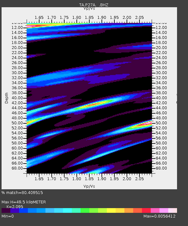
| Estimated Moho Depth: |
49.5 km |
| Estimated Crust Vp/Vs: |
2.10 |
| Assumed Crust Vp: |
6.242 km/s |
| Estimated Crust Vs: |
2.979 km/s |
| Estimated Crust Poisson's Ratio: |
0.35 |
|
| Radial Match: |
80.409515 % |
| Radial Bump: |
400 |
| Transverse Match: |
58.509544 % |
| Transverse Bump: |
400 |
| SOD ConfigId: |
314592 |
| Insert Time: |
2010-09-04 07:31:21.855 +0000 |
| GWidth: |
2.5 |
| Max Bumps: |
400 |
| Tol: |
0.001 |
|
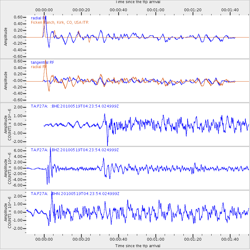
Signal To Noise
| Channel | StoN | STA | LTA |
| TA:P27A: :BHZ:20100519T04:23:54.024999Z | 18.355278 | 2.4983133E-6 | 1.3610871E-7 |
| TA:P27A: :BHN:20100519T04:23:54.024999Z | 2.9144027 | 9.1494167E-7 | 3.1393796E-7 |
| TA:P27A: :BHE:20100519T04:23:54.024999Z | 4.895303 | 7.7878167E-7 | 1.5908753E-7 |
| Arrivals |
| Ps | 9.1 SECOND |
| PpPs | 23 SECOND |
| PsPs/PpSs | 33 SECOND |


