You are here: Home > Network List > TA - USArray Transportable Network (new EarthScope stations) Stations List
> Station 429A Davenport Ranch, Sheffield, TX, USA > Earthquake Result Viewer
429A Davenport Ranch, Sheffield, TX, USA - Earthquake Result Viewer
| Earthquake location: |
Northern Peru |
| Earthquake latitude/longitude: |
-5.1/-77.5 |
| Earthquake time(UTC): |
2010/05/19 (139) 04:15:44 GMT |
| Earthquake Depth: |
140 km |
| Earthquake Magnitude: |
6.0 MB, 6.0 MW, 6.0 MW |
| Earthquake Catalog/Contributor: |
WHDF/NEIC |
|
| Network: |
TA USArray Transportable Network (new EarthScope stations) |
| Station: |
429A Davenport Ranch, Sheffield, TX, USA |
| Lat/Lon: |
30.62 N/101.89 W |
| Elevation: |
804 m |
|
| Distance: |
42.5 deg |
| Az: |
328.223 deg |
| Baz: |
142.515 deg |
| Ray Param: |
0.072652064 |
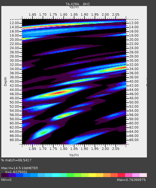
| Estimated Moho Depth: |
14.5 km |
| Estimated Crust Vp/Vs: |
1.62 |
| Assumed Crust Vp: |
6.38 km/s |
| Estimated Crust Vs: |
3.933 km/s |
| Estimated Crust Poisson's Ratio: |
0.19 |
|
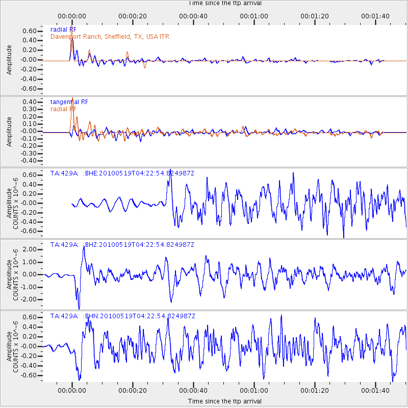
| Radial Match: |
86.5417 % |
| Radial Bump: |
400 |
| Transverse Match: |
74.851715 % |
| Transverse Bump: |
400 |
| SOD ConfigId: |
314592 |
| Insert Time: |
2010-09-04 07:31:58.478 +0000 |
| GWidth: |
2.5 |
| Max Bumps: |
400 |
| Tol: |
0.001 |
|
Signal To Noise
| Channel | StoN | STA | LTA |
| TA:429A: :BHZ:20100519T04:22:54.824987Z | 17.228254 | 1.3018672E-6 | 7.556582E-8 |
| TA:429A: :BHN:20100519T04:22:54.824987Z | 7.0778604 | 3.508054E-7 | 4.9563766E-8 |
| TA:429A: :BHE:20100519T04:22:54.824987Z | 4.4921346 | 3.1941278E-7 | 7.110489E-8 |
| Arrivals |
| Ps | 1.5 SECOND |
| PpPs | 5.5 SECOND |
| PsPs/PpSs | 7.1 SECOND |


