You are here: Home > Network List > TA - USArray Transportable Network (new EarthScope stations) Stations List
> Station 732A Laxson Ranch, Crystal City, TX, USA > Earthquake Result Viewer
732A Laxson Ranch, Crystal City, TX, USA - Earthquake Result Viewer
| Earthquake location: |
Northern Peru |
| Earthquake latitude/longitude: |
-5.1/-77.5 |
| Earthquake time(UTC): |
2010/05/19 (139) 04:15:44 GMT |
| Earthquake Depth: |
140 km |
| Earthquake Magnitude: |
6.0 MB, 6.0 MW, 6.0 MW |
| Earthquake Catalog/Contributor: |
WHDF/NEIC |
|
| Network: |
TA USArray Transportable Network (new EarthScope stations) |
| Station: |
732A Laxson Ranch, Crystal City, TX, USA |
| Lat/Lon: |
28.73 N/99.97 W |
| Elevation: |
178 m |
|
| Distance: |
39.9 deg |
| Az: |
328.533 deg |
| Baz: |
143.696 deg |
| Ray Param: |
0.07419052 |
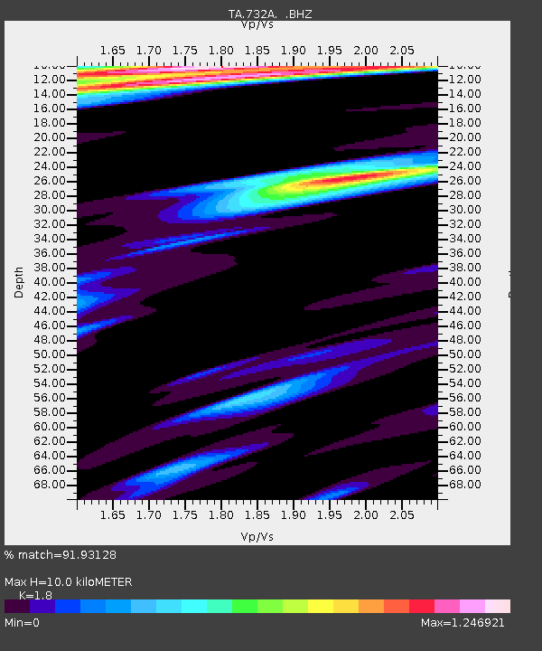
| Estimated Moho Depth: |
10.0 km |
| Estimated Crust Vp/Vs: |
1.80 |
| Assumed Crust Vp: |
6.347 km/s |
| Estimated Crust Vs: |
3.526 km/s |
| Estimated Crust Poisson's Ratio: |
0.28 |
|
| Radial Match: |
91.93128 % |
| Radial Bump: |
399 |
| Transverse Match: |
87.981384 % |
| Transverse Bump: |
400 |
| SOD ConfigId: |
314592 |
| Insert Time: |
2010-09-04 07:32:19.545 +0000 |
| GWidth: |
2.5 |
| Max Bumps: |
400 |
| Tol: |
0.001 |
|
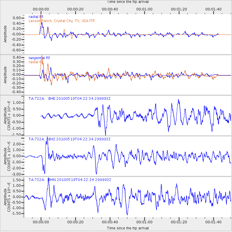
Signal To Noise
| Channel | StoN | STA | LTA |
| TA:732A: :BHZ:20100519T04:22:34.299993Z | 26.16482 | 1.6609796E-6 | 6.348141E-8 |
| TA:732A: :BHN:20100519T04:22:34.299993Z | 10.6065645 | 7.2443345E-7 | 6.830048E-8 |
| TA:732A: :BHE:20100519T04:22:34.299993Z | 4.587058 | 4.3928117E-7 | 9.576534E-8 |
| Arrivals |
| Ps | 1.3 SECOND |
| PpPs | 4.1 SECOND |
| PsPs/PpSs | 5.5 SECOND |


