You are here: Home > Network List > TA - USArray Transportable Network (new EarthScope stations) Stations List
> Station 230A Sterling City, TX, USA > Earthquake Result Viewer
230A Sterling City, TX, USA - Earthquake Result Viewer
| Earthquake location: |
Northern Peru |
| Earthquake latitude/longitude: |
-5.1/-77.5 |
| Earthquake time(UTC): |
2010/05/19 (139) 04:15:44 GMT |
| Earthquake Depth: |
140 km |
| Earthquake Magnitude: |
6.0 MB, 6.0 MW, 6.0 MW |
| Earthquake Catalog/Contributor: |
WHDF/NEIC |
|
| Network: |
TA USArray Transportable Network (new EarthScope stations) |
| Station: |
230A Sterling City, TX, USA |
| Lat/Lon: |
31.89 N/101.11 W |
| Elevation: |
742 m |
|
| Distance: |
43.1 deg |
| Az: |
330.119 deg |
| Baz: |
144.311 deg |
| Ray Param: |
0.07225889 |
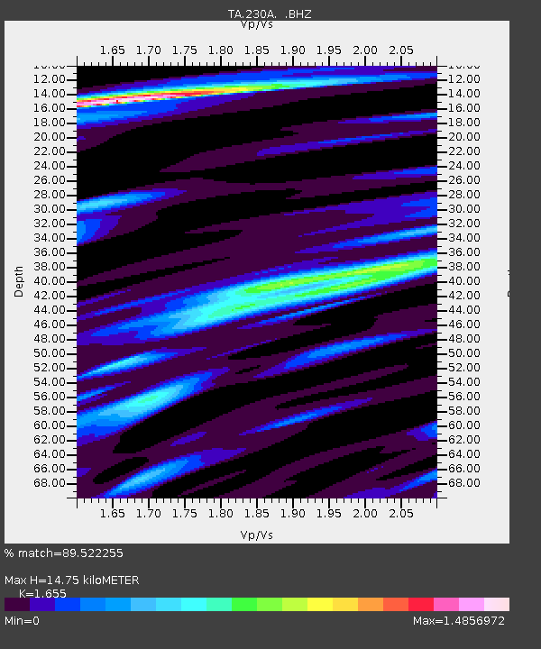
| Estimated Moho Depth: |
14.75 km |
| Estimated Crust Vp/Vs: |
1.65 |
| Assumed Crust Vp: |
6.38 km/s |
| Estimated Crust Vs: |
3.855 km/s |
| Estimated Crust Poisson's Ratio: |
0.21 |
|
| Radial Match: |
89.522255 % |
| Radial Bump: |
400 |
| Transverse Match: |
73.41591 % |
| Transverse Bump: |
400 |
| SOD ConfigId: |
314592 |
| Insert Time: |
2010-09-04 07:32:59.451 +0000 |
| GWidth: |
2.5 |
| Max Bumps: |
400 |
| Tol: |
0.001 |
|

Signal To Noise
| Channel | StoN | STA | LTA |
| TA:230A: :BHZ:20100519T04:22:59.750005Z | 19.834248 | 1.6241702E-6 | 8.188716E-8 |
| TA:230A: :BHN:20100519T04:22:59.750005Z | 11.153706 | 9.91497E-7 | 8.889396E-8 |
| TA:230A: :BHE:20100519T04:22:59.750005Z | 9.718253 | 6.604562E-7 | 6.796038E-8 |
| Arrivals |
| Ps | 1.6 SECOND |
| PpPs | 5.7 SECOND |
| PsPs/PpSs | 7.3 SECOND |


