You are here: Home > Network List > US - United States National Seismic Network Stations List
> Station EGMT Eagleton, Montana, USA > Earthquake Result Viewer
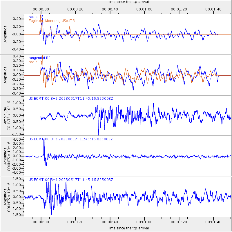
EGMT Eagleton, Montana, USA - Earthquake Result Viewer
*The percent match for this event was below the threshold and hence no stack was calculated.
| Earthquake location: |
Northwest Of Kuril Islands |
| Earthquake latitude/longitude: |
48.0/147.4 |
| Earthquake time(UTC): |
2023/06/17 (168) 11:36:00 GMT |
| Earthquake Depth: |
418 km |
| Earthquake Magnitude: |
5.7 mww |
| Earthquake Catalog/Contributor: |
NEIC PDE/us |
|
| Network: |
US United States National Seismic Network |
| Station: |
EGMT Eagleton, Montana, USA |
| Lat/Lon: |
48.02 N/109.75 W |
| Elevation: |
1055 m |
|
| Distance: |
63.4 deg |
| Az: |
47.056 deg |
| Baz: |
312.862 deg |
| Ray Param: |
$rayparam |
*The percent match for this event was below the threshold and hence was not used in the summary stack. |
|
| Radial Match: |
73.64647 % |
| Radial Bump: |
400 |
| Transverse Match: |
74.487045 % |
| Transverse Bump: |
400 |
| SOD ConfigId: |
30536071 |
| Insert Time: |
2023-07-01 12:23:11.630 +0000 |
| GWidth: |
2.5 |
| Max Bumps: |
400 |
| Tol: |
0.001 |
|
Signal To Noise
| Channel | StoN | STA | LTA |
| US:EGMT:00:BHZ:20230617T11:45:16.825003Z | 9.004533 | 1.314303E-6 | 1.4596014E-7 |
| US:EGMT:00:BH1:20230617T11:45:16.825003Z | 3.3080673 | 5.463244E-7 | 1.651491E-7 |
| US:EGMT:00:BH2:20230617T11:45:16.825003Z | 3.0977893 | 4.914362E-7 | 1.5864093E-7 |
| Arrivals |
| Ps | |
| PpPs | |
| PsPs/PpSs | |


