You are here: Home > Network List > US - United States National Seismic Network Stations List
> Station HAWA Hanford, Washington, USA > Earthquake Result Viewer
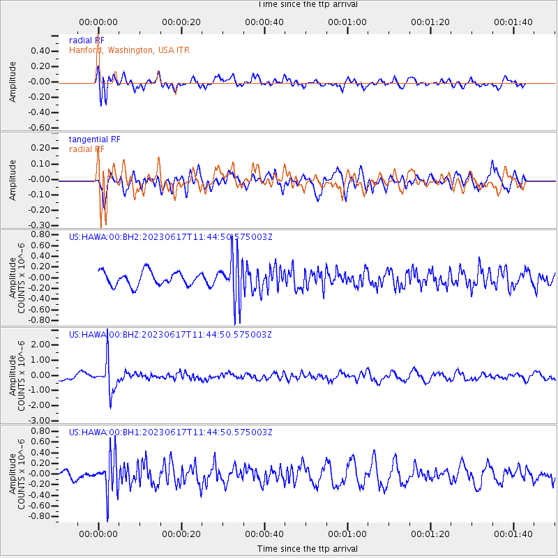
HAWA Hanford, Washington, USA - Earthquake Result Viewer
*The percent match for this event was below the threshold and hence no stack was calculated.
| Earthquake location: |
Northwest Of Kuril Islands |
| Earthquake latitude/longitude: |
48.0/147.4 |
| Earthquake time(UTC): |
2023/06/17 (168) 11:36:00 GMT |
| Earthquake Depth: |
418 km |
| Earthquake Magnitude: |
5.7 mww |
| Earthquake Catalog/Contributor: |
NEIC PDE/us |
|
| Network: |
US United States National Seismic Network |
| Station: |
HAWA Hanford, Washington, USA |
| Lat/Lon: |
46.39 N/119.53 W |
| Elevation: |
364 m |
|
| Distance: |
59.4 deg |
| Az: |
53.418 deg |
| Baz: |
308.751 deg |
| Ray Param: |
$rayparam |
*The percent match for this event was below the threshold and hence was not used in the summary stack. |
|
| Radial Match: |
55.360878 % |
| Radial Bump: |
400 |
| Transverse Match: |
51.606365 % |
| Transverse Bump: |
400 |
| SOD ConfigId: |
30536071 |
| Insert Time: |
2023-07-01 12:23:18.232 +0000 |
| GWidth: |
2.5 |
| Max Bumps: |
400 |
| Tol: |
0.001 |
|
Signal To Noise
| Channel | StoN | STA | LTA |
| US:HAWA:00:BHZ:20230617T11:44:50.575003Z | 7.681118 | 1.0446623E-6 | 1.3600393E-7 |
| US:HAWA:00:BH1:20230617T11:44:50.575003Z | 3.840127 | 3.4811774E-7 | 9.0652655E-8 |
| US:HAWA:00:BH2:20230617T11:44:50.575003Z | 3.1353068 | 4.0073851E-7 | 1.2781477E-7 |
| Arrivals |
| Ps | |
| PpPs | |
| PsPs/PpSs | |


