You are here: Home > Network List > TA - USArray Transportable Network (new EarthScope stations) Stations List
> Station Z30A Sanderson Ranch, Post, TX, USA > Earthquake Result Viewer
Z30A Sanderson Ranch, Post, TX, USA - Earthquake Result Viewer
| Earthquake location: |
Northern Peru |
| Earthquake latitude/longitude: |
-5.1/-77.5 |
| Earthquake time(UTC): |
2010/05/19 (139) 04:15:44 GMT |
| Earthquake Depth: |
140 km |
| Earthquake Magnitude: |
6.0 MB, 6.0 MW, 6.0 MW |
| Earthquake Catalog/Contributor: |
WHDF/NEIC |
|
| Network: |
TA USArray Transportable Network (new EarthScope stations) |
| Station: |
Z30A Sanderson Ranch, Post, TX, USA |
| Lat/Lon: |
33.29 N/101.13 W |
| Elevation: |
729 m |
|
| Distance: |
44.2 deg |
| Az: |
331.27 deg |
| Baz: |
145.135 deg |
| Ray Param: |
0.07155217 |
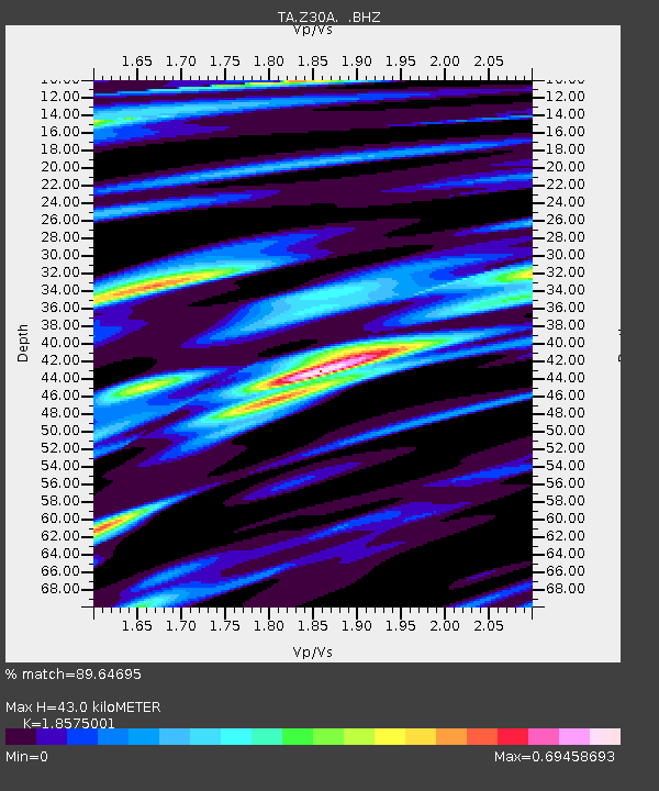
| Estimated Moho Depth: |
43.0 km |
| Estimated Crust Vp/Vs: |
1.86 |
| Assumed Crust Vp: |
6.426 km/s |
| Estimated Crust Vs: |
3.46 km/s |
| Estimated Crust Poisson's Ratio: |
0.30 |
|
| Radial Match: |
89.64695 % |
| Radial Bump: |
400 |
| Transverse Match: |
76.73901 % |
| Transverse Bump: |
400 |
| SOD ConfigId: |
314592 |
| Insert Time: |
2010-09-04 07:33:31.801 +0000 |
| GWidth: |
2.5 |
| Max Bumps: |
400 |
| Tol: |
0.001 |
|
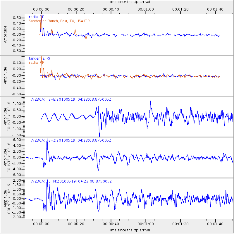
Signal To Noise
| Channel | StoN | STA | LTA |
| TA:Z30A: :BHZ:20100519T04:23:08.875005Z | 20.348572 | 2.369429E-6 | 1.1644203E-7 |
| TA:Z30A: :BHN:20100519T04:23:08.875005Z | 8.357993 | 9.251162E-7 | 1.1068641E-7 |
| TA:Z30A: :BHE:20100519T04:23:08.875005Z | 3.3521235 | 5.8544674E-7 | 1.746495E-7 |
| Arrivals |
| Ps | 6.1 SECOND |
| PpPs | 18 SECOND |
| PsPs/PpSs | 24 SECOND |


