You are here: Home > Network List > TA - USArray Transportable Network (new EarthScope stations) Stations List
> Station V30A Spur Ranch, Miami, TX, USA > Earthquake Result Viewer
V30A Spur Ranch, Miami, TX, USA - Earthquake Result Viewer
| Earthquake location: |
Northern Peru |
| Earthquake latitude/longitude: |
-5.1/-77.5 |
| Earthquake time(UTC): |
2010/05/19 (139) 04:15:44 GMT |
| Earthquake Depth: |
140 km |
| Earthquake Magnitude: |
6.0 MB, 6.0 MW, 6.0 MW |
| Earthquake Catalog/Contributor: |
WHDF/NEIC |
|
| Network: |
TA USArray Transportable Network (new EarthScope stations) |
| Station: |
V30A Spur Ranch, Miami, TX, USA |
| Lat/Lon: |
35.76 N/100.69 W |
| Elevation: |
931 m |
|
| Distance: |
46.1 deg |
| Az: |
333.638 deg |
| Baz: |
147.054 deg |
| Ray Param: |
0.07038026 |
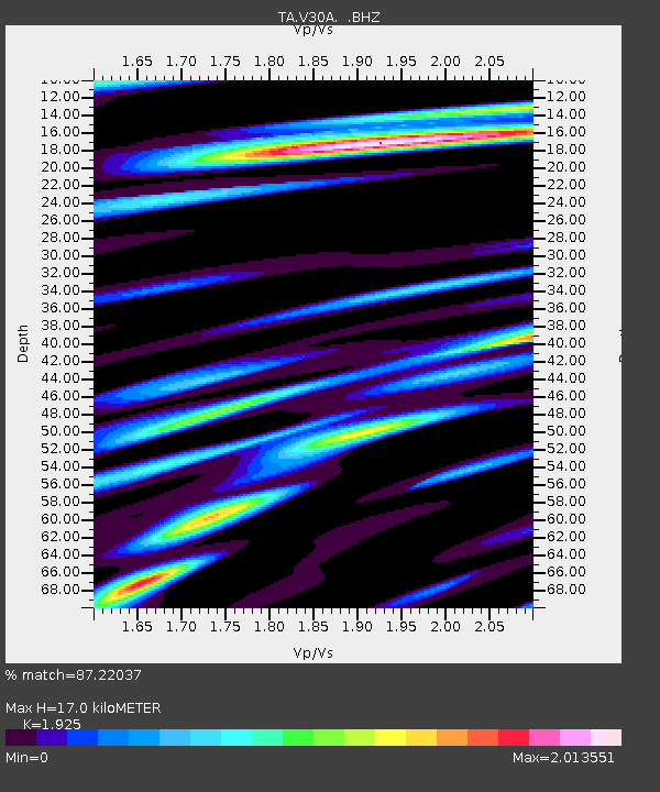
| Estimated Moho Depth: |
17.0 km |
| Estimated Crust Vp/Vs: |
1.92 |
| Assumed Crust Vp: |
6.426 km/s |
| Estimated Crust Vs: |
3.338 km/s |
| Estimated Crust Poisson's Ratio: |
0.32 |
|
| Radial Match: |
87.22037 % |
| Radial Bump: |
400 |
| Transverse Match: |
80.82047 % |
| Transverse Bump: |
400 |
| SOD ConfigId: |
314592 |
| Insert Time: |
2010-09-04 07:34:33.118 +0000 |
| GWidth: |
2.5 |
| Max Bumps: |
400 |
| Tol: |
0.001 |
|

Signal To Noise
| Channel | StoN | STA | LTA |
| TA:V30A: :BHZ:20100519T04:23:23.449987Z | 10.846926 | 2.963457E-6 | 2.732071E-7 |
| TA:V30A: :BHN:20100519T04:23:23.449987Z | 4.6515336 | 1.4350816E-6 | 3.0851794E-7 |
| TA:V30A: :BHE:20100519T04:23:23.449987Z | 3.4730682 | 8.218423E-7 | 2.3663294E-7 |
| Arrivals |
| Ps | 2.6 SECOND |
| PpPs | 7.3 SECOND |
| PsPs/PpSs | 9.9 SECOND |


