You are here: Home > Network List > G - GEOSCOPE Stations List
> Station MPG Montagne des Peres, French Guyana > Earthquake Result Viewer
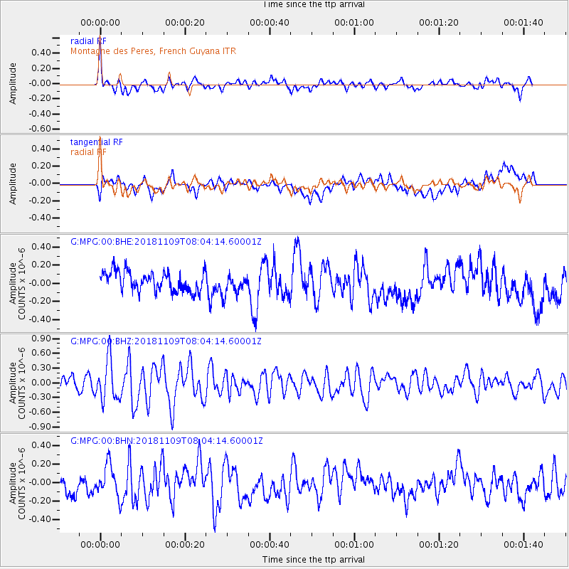
MPG Montagne des Peres, French Guyana - Earthquake Result Viewer
*The percent match for this event was below the threshold and hence no stack was calculated.
| Earthquake location: |
Southern Mid-Atlantic Ridge |
| Earthquake latitude/longitude: |
-42.7/-16.0 |
| Earthquake time(UTC): |
2018/11/09 (313) 07:54:52 GMT |
| Earthquake Depth: |
10 km |
| Earthquake Magnitude: |
5.8 Mww |
| Earthquake Catalog/Contributor: |
NEIC PDE/us |
|
| Network: |
G GEOSCOPE |
| Station: |
MPG Montagne des Peres, French Guyana |
| Lat/Lon: |
5.11 N/52.64 W |
| Elevation: |
147 m |
|
| Distance: |
58.0 deg |
| Az: |
315.526 deg |
| Baz: |
148.777 deg |
| Ray Param: |
$rayparam |
*The percent match for this event was below the threshold and hence was not used in the summary stack. |
|
| Radial Match: |
66.70791 % |
| Radial Bump: |
400 |
| Transverse Match: |
51.40884 % |
| Transverse Bump: |
400 |
| SOD ConfigId: |
3131071 |
| Insert Time: |
2018-11-23 07:56:28.081 +0000 |
| GWidth: |
2.5 |
| Max Bumps: |
400 |
| Tol: |
0.001 |
|
Signal To Noise
| Channel | StoN | STA | LTA |
| G:MPG:00:BHZ:20181109T08:04:14.60001Z | 3.3418286 | 4.255398E-7 | 1.2733742E-7 |
| G:MPG:00:BHN:20181109T08:04:14.60001Z | 1.5094713 | 1.7793175E-7 | 1.17876866E-7 |
| G:MPG:00:BHE:20181109T08:04:14.60001Z | 1.002103 | 1.076213E-7 | 1.07395444E-7 |
| Arrivals |
| Ps | |
| PpPs | |
| PsPs/PpSs | |


