You are here: Home > Network List > UW - Pacific Northwest Regional Seismic Network Stations List
> Station UMAT Pilot Rock, OR, USA > Earthquake Result Viewer
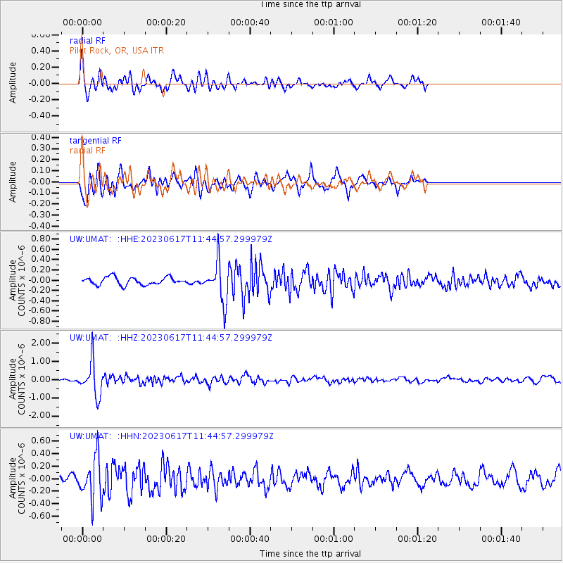
UMAT Pilot Rock, OR, USA - Earthquake Result Viewer
*The percent match for this event was below the threshold and hence no stack was calculated.
| Earthquake location: |
Northwest Of Kuril Islands |
| Earthquake latitude/longitude: |
48.0/147.4 |
| Earthquake time(UTC): |
2023/06/17 (168) 11:36:00 GMT |
| Earthquake Depth: |
418 km |
| Earthquake Magnitude: |
5.7 mww |
| Earthquake Catalog/Contributor: |
NEIC PDE/us |
|
| Network: |
UW Pacific Northwest Regional Seismic Network |
| Station: |
UMAT Pilot Rock, OR, USA |
| Lat/Lon: |
45.29 N/118.96 W |
| Elevation: |
1318 m |
|
| Distance: |
60.4 deg |
| Az: |
54.115 deg |
| Baz: |
309.51 deg |
| Ray Param: |
$rayparam |
*The percent match for this event was below the threshold and hence was not used in the summary stack. |
|
| Radial Match: |
72.976036 % |
| Radial Bump: |
400 |
| Transverse Match: |
64.68799 % |
| Transverse Bump: |
400 |
| SOD ConfigId: |
30536071 |
| Insert Time: |
2023-07-01 12:27:56.828 +0000 |
| GWidth: |
2.5 |
| Max Bumps: |
400 |
| Tol: |
0.001 |
|
Signal To Noise
| Channel | StoN | STA | LTA |
| UW:UMAT: :HHZ:20230617T11:44:57.299979Z | 8.191899 | 9.4865635E-7 | 1.158042E-7 |
| UW:UMAT: :HHN:20230617T11:44:57.299979Z | 5.1985245 | 3.3927665E-7 | 6.526403E-8 |
| UW:UMAT: :HHE:20230617T11:44:57.299979Z | 5.4067507 | 3.960377E-7 | 7.324875E-8 |
| Arrivals |
| Ps | |
| PpPs | |
| PsPs/PpSs | |


