You are here: Home > Network List > TA - USArray Transportable Network (new EarthScope stations) Stations List
> Station M29A Burnside Ranch, Stapleton, NE, USA > Earthquake Result Viewer
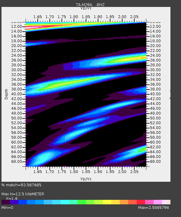
M29A Burnside Ranch, Stapleton, NE, USA - Earthquake Result Viewer
| Earthquake location: |
Northern Peru |
| Earthquake latitude/longitude: |
-5.1/-77.5 |
| Earthquake time(UTC): |
2010/05/19 (139) 04:15:44 GMT |
| Earthquake Depth: |
140 km |
| Earthquake Magnitude: |
6.0 MB, 6.0 MW, 6.0 MW |
| Earthquake Catalog/Contributor: |
WHDF/NEIC |
|
| Network: |
TA USArray Transportable Network (new EarthScope stations) |
| Station: |
M29A Burnside Ranch, Stapleton, NE, USA |
| Lat/Lon: |
41.44 N/100.69 W |
| Elevation: |
952 m |
|
| Distance: |
50.9 deg |
| Az: |
337.611 deg |
| Baz: |
149.69 deg |
| Ray Param: |
0.06728485 |
| Estimated Moho Depth: |
12.5 km |
| Estimated Crust Vp/Vs: |
1.60 |
| Assumed Crust Vp: |
6.483 km/s |
| Estimated Crust Vs: |
4.052 km/s |
| Estimated Crust Poisson's Ratio: |
0.18 |
|
| Radial Match: |
93.567665 % |
| Radial Bump: |
378 |
| Transverse Match: |
66.28647 % |
| Transverse Bump: |
400 |
| SOD ConfigId: |
314592 |
| Insert Time: |
2010-09-04 07:36:09.830 +0000 |
| GWidth: |
2.5 |
| Max Bumps: |
400 |
| Tol: |
0.001 |
|

Signal To Noise
| Channel | StoN | STA | LTA |
| TA:M29A: :BHZ:20100519T04:24:00.350011Z | 22.991095 | 3.7814484E-6 | 1.6447449E-7 |
| TA:M29A: :BHN:20100519T04:24:00.350011Z | 9.298415 | 2.241969E-6 | 2.41113E-7 |
| TA:M29A: :BHE:20100519T04:24:00.350011Z | 5.0599613 | 1.6430763E-6 | 3.247211E-7 |
| Arrivals |
| Ps | 1.2 SECOND |
| PpPs | 4.7 SECOND |
| PsPs/PpSs | 5.9 SECOND |


