You are here: Home > Network List > TA - USArray Transportable Network (new EarthScope stations) Stations List
> Station H28A Mission Ridge, SD, USA > Earthquake Result Viewer
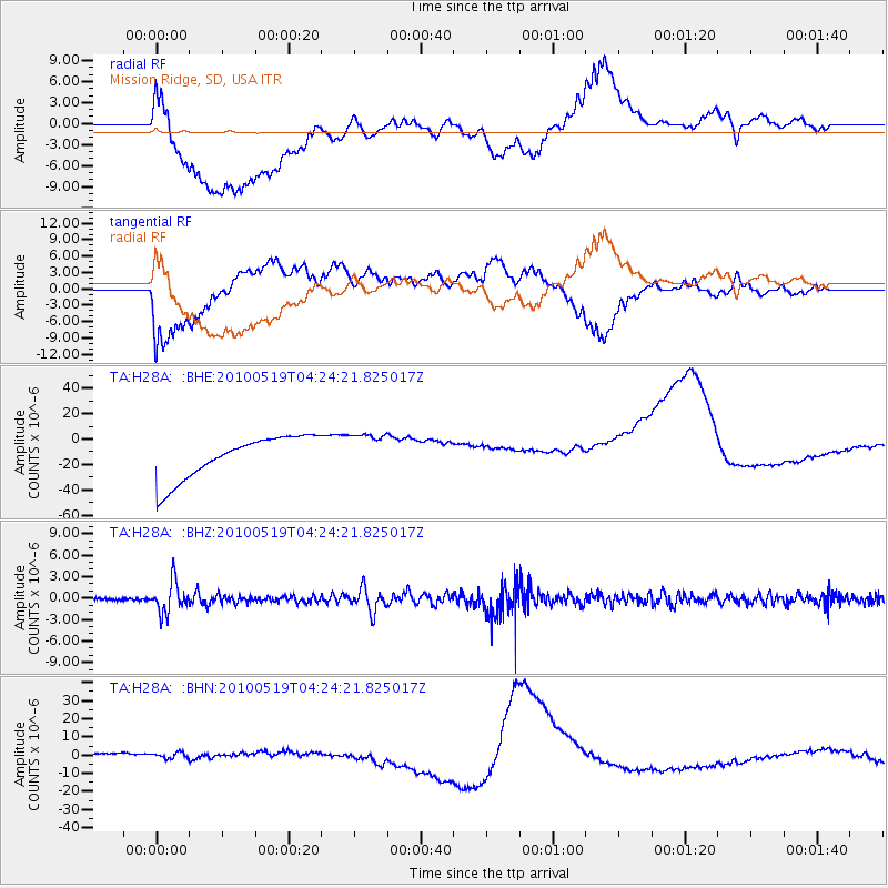
H28A Mission Ridge, SD, USA - Earthquake Result Viewer
*The percent match for this event was below the threshold and hence no stack was calculated.
| Earthquake location: |
Northern Peru |
| Earthquake latitude/longitude: |
-5.1/-77.5 |
| Earthquake time(UTC): |
2010/05/19 (139) 04:15:44 GMT |
| Earthquake Depth: |
140 km |
| Earthquake Magnitude: |
6.0 MB, 6.0 MW, 6.0 MW |
| Earthquake Catalog/Contributor: |
WHDF/NEIC |
|
| Network: |
TA USArray Transportable Network (new EarthScope stations) |
| Station: |
H28A Mission Ridge, SD, USA |
| Lat/Lon: |
44.68 N/101.02 W |
| Elevation: |
642 m |
|
| Distance: |
53.8 deg |
| Az: |
339.377 deg |
| Baz: |
150.543 deg |
| Ray Param: |
$rayparam |
*The percent match for this event was below the threshold and hence was not used in the summary stack. |
|
| Radial Match: |
52.26732 % |
| Radial Bump: |
400 |
| Transverse Match: |
46.083416 % |
| Transverse Bump: |
400 |
| SOD ConfigId: |
314592 |
| Insert Time: |
2010-09-04 07:38:17.199 +0000 |
| GWidth: |
2.5 |
| Max Bumps: |
400 |
| Tol: |
0.001 |
|
Signal To Noise
| Channel | StoN | STA | LTA |
| TA:H28A: :BHZ:20100519T04:24:21.825017Z | 11.9288845 | 2.1540804E-6 | 1.8057686E-7 |
| TA:H28A: :BHN:20100519T04:24:21.825017Z | 0.8265975 | 6.317822E-6 | 7.643166E-6 |
| TA:H28A: :BHE:20100519T04:24:21.825017Z | 0.93834865 | 1.5779422E-5 | 1.681616E-5 |
| Arrivals |
| Ps | |
| PpPs | |
| PsPs/PpSs | |


