You are here: Home > Network List > TA - USArray Transportable Network (new EarthScope stations) Stations List
> Station E27A Carson, ND, USA > Earthquake Result Viewer
E27A Carson, ND, USA - Earthquake Result Viewer
| Earthquake location: |
Northern Peru |
| Earthquake latitude/longitude: |
-5.1/-77.5 |
| Earthquake time(UTC): |
2010/05/19 (139) 04:15:44 GMT |
| Earthquake Depth: |
140 km |
| Earthquake Magnitude: |
6.0 MB, 6.0 MW, 6.0 MW |
| Earthquake Catalog/Contributor: |
WHDF/NEIC |
|
| Network: |
TA USArray Transportable Network (new EarthScope stations) |
| Station: |
E27A Carson, ND, USA |
| Lat/Lon: |
46.43 N/101.56 W |
| Elevation: |
738 m |
|
| Distance: |
55.5 deg |
| Az: |
340.026 deg |
| Baz: |
150.531 deg |
| Ray Param: |
0.0642786 |
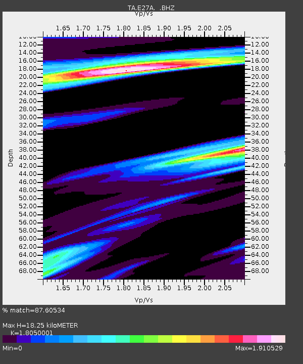
| Estimated Moho Depth: |
18.25 km |
| Estimated Crust Vp/Vs: |
1.81 |
| Assumed Crust Vp: |
6.438 km/s |
| Estimated Crust Vs: |
3.566 km/s |
| Estimated Crust Poisson's Ratio: |
0.28 |
|
| Radial Match: |
87.60534 % |
| Radial Bump: |
400 |
| Transverse Match: |
73.57 % |
| Transverse Bump: |
400 |
| SOD ConfigId: |
314592 |
| Insert Time: |
2010-09-04 07:39:15.596 +0000 |
| GWidth: |
2.5 |
| Max Bumps: |
400 |
| Tol: |
0.001 |
|

Signal To Noise
| Channel | StoN | STA | LTA |
| TA:E27A: :BHZ:20100519T04:24:34.174993Z | 27.667784 | 3.5353405E-6 | 1.2777824E-7 |
| TA:E27A: :BHN:20100519T04:24:34.174993Z | 2.3287141 | 1.3940358E-6 | 5.98629E-7 |
| TA:E27A: :BHE:20100519T04:24:34.174993Z | 1.3584167 | 8.879111E-7 | 6.536368E-7 |
| Arrivals |
| Ps | 2.4 SECOND |
| PpPs | 7.6 SECOND |
| PsPs/PpSs | 10.0 SECOND |


