You are here: Home > Network List > IU - Global Seismograph Network (GSN - IRIS/USGS) Stations List
> Station PMG Port Moresby, New Guinea > Earthquake Result Viewer
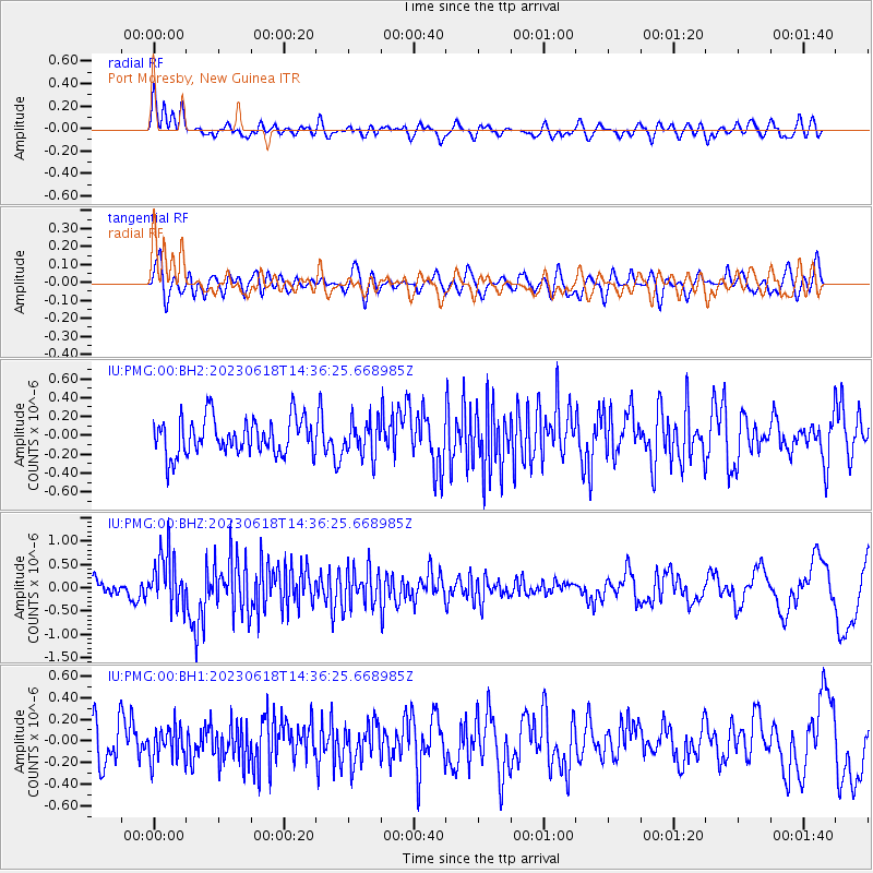
PMG Port Moresby, New Guinea - Earthquake Result Viewer
*The percent match for this event was below the threshold and hence no stack was calculated.
| Earthquake location: |
Tonga Islands Region |
| Earthquake latitude/longitude: |
-24.0/-175.8 |
| Earthquake time(UTC): |
2023/06/18 (169) 14:29:39 GMT |
| Earthquake Depth: |
28 km |
| Earthquake Magnitude: |
5.7 Mww |
| Earthquake Catalog/Contributor: |
NEIC PDE/us |
|
| Network: |
IU Global Seismograph Network (GSN - IRIS/USGS) |
| Station: |
PMG Port Moresby, New Guinea |
| Lat/Lon: |
9.40 S/147.16 E |
| Elevation: |
90 m |
|
| Distance: |
38.2 deg |
| Az: |
285.932 deg |
| Baz: |
116.945 deg |
| Ray Param: |
$rayparam |
*The percent match for this event was below the threshold and hence was not used in the summary stack. |
|
| Radial Match: |
66.9261 % |
| Radial Bump: |
400 |
| Transverse Match: |
46.82463 % |
| Transverse Bump: |
400 |
| SOD ConfigId: |
30536071 |
| Insert Time: |
2023-07-02 14:42:41.720 +0000 |
| GWidth: |
2.5 |
| Max Bumps: |
400 |
| Tol: |
0.001 |
|
Signal To Noise
| Channel | StoN | STA | LTA |
| IU:PMG:00:BHZ:20230618T14:36:25.668985Z | 3.6107094 | 5.7385E-7 | 1.5892998E-7 |
| IU:PMG:00:BH1:20230618T14:36:25.668985Z | 0.84516996 | 1.5345994E-7 | 1.8157287E-7 |
| IU:PMG:00:BH2:20230618T14:36:25.668985Z | 0.9803939 | 1.9035103E-7 | 1.9415772E-7 |
| Arrivals |
| Ps | |
| PpPs | |
| PsPs/PpSs | |


