You are here: Home > Network List > TA - USArray Transportable Network (new EarthScope stations) Stations List
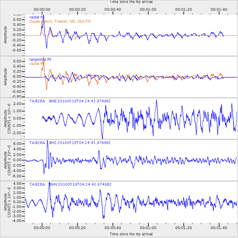
> Station B28A Dugan Ranch, Towner, ND, USA > Earthquake Result Viewer
B28A Dugan Ranch, Towner, ND, USA - Earthquake Result Viewer
| Earthquake location: |
Northern Peru |
| Earthquake latitude/longitude: |
-5.1/-77.5 |
| Earthquake time(UTC): |
2010/05/19 (139) 04:15:44 GMT |
| Earthquake Depth: |
140 km |
| Earthquake Magnitude: |
6.0 MB, 6.0 MW, 6.0 MW |
| Earthquake Catalog/Contributor: |
WHDF/NEIC |
|
| Network: |
TA USArray Transportable Network (new EarthScope stations) |
| Station: |
B28A Dugan Ranch, Towner, ND, USA |
| Lat/Lon: |
48.45 N/100.36 W |
| Elevation: |
451 m |
|
| Distance: |
56.9 deg |
| Az: |
342.048 deg |
| Baz: |
152.539 deg |
| Ray Param: |
0.06338567 |
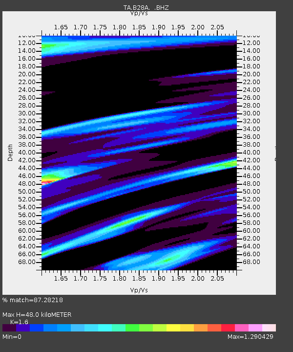
| Estimated Moho Depth: |
48.0 km |
| Estimated Crust Vp/Vs: |
1.60 |
| Assumed Crust Vp: |
6.438 km/s |
| Estimated Crust Vs: |
4.023 km/s |
| Estimated Crust Poisson's Ratio: |
0.18 |
|
| Radial Match: |
87.28218 % |
| Radial Bump: |
289 |
| Transverse Match: |
69.03633 % |
| Transverse Bump: |
400 |
| SOD ConfigId: |
314592 |
| Insert Time: |
2010-09-04 07:40:19.658 +0000 |
| GWidth: |
2.5 |
| Max Bumps: |
400 |
| Tol: |
0.001 |
|
Signal To Noise
| Channel | StoN | STA | LTA |
| TA:B28A: :BHZ:20100519T04:24:43.97498Z | 14.025304 | 2.8715488E-6 | 2.0474057E-7 |
| TA:B28A: :BHN:20100519T04:24:43.97498Z | 3.3677351 | 1.7859577E-6 | 5.3031414E-7 |
| TA:B28A: :BHE:20100519T04:24:43.97498Z | 2.6261902 | 1.158551E-6 | 4.411527E-7 |
| Arrivals |
| Ps | 4.7 SECOND |
| PpPs | 18 SECOND |
| PsPs/PpSs | 23 SECOND |


