You are here: Home > Network List > AK - Alaska Regional Network Stations List
> Station DHY Denali Highway > Earthquake Result Viewer
DHY Denali Highway - Earthquake Result Viewer
| Earthquake location: |
Tonga Islands Region |
| Earthquake latitude/longitude: |
-23.8/-175.7 |
| Earthquake time(UTC): |
2023/06/18 (169) 15:04:49 GMT |
| Earthquake Depth: |
10 km |
| Earthquake Magnitude: |
5.8 Mww |
| Earthquake Catalog/Contributor: |
NEIC PDE/us |
|
| Network: |
AK Alaska Regional Network |
| Station: |
DHY Denali Highway |
| Lat/Lon: |
63.08 N/147.38 W |
| Elevation: |
1609 m |
|
| Distance: |
89.4 deg |
| Az: |
12.49 deg |
| Baz: |
205.8 deg |
| Ray Param: |
0.041865442 |
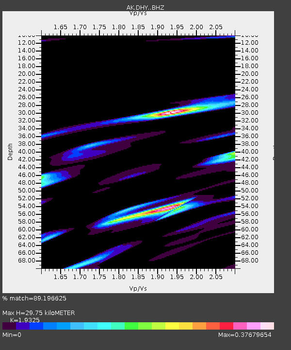
| Estimated Moho Depth: |
29.75 km |
| Estimated Crust Vp/Vs: |
1.93 |
| Assumed Crust Vp: |
6.566 km/s |
| Estimated Crust Vs: |
3.398 km/s |
| Estimated Crust Poisson's Ratio: |
0.32 |
|
| Radial Match: |
89.196625 % |
| Radial Bump: |
400 |
| Transverse Match: |
91.00941 % |
| Transverse Bump: |
400 |
| SOD ConfigId: |
30536071 |
| Insert Time: |
2023-07-02 15:08:07.361 +0000 |
| GWidth: |
2.5 |
| Max Bumps: |
400 |
| Tol: |
0.001 |
|

Signal To Noise
| Channel | StoN | STA | LTA |
| AK:DHY: :BHZ:20230618T15:17:15.027975Z | 2.223315 | 5.5024816E-7 | 2.4748996E-7 |
| AK:DHY: :BHN:20230618T15:17:15.027975Z | 1.7193758 | 3.5844565E-7 | 2.0847429E-7 |
| AK:DHY: :BHE:20230618T15:17:15.027975Z | 1.2348748 | 3.4677018E-7 | 2.8081405E-7 |
| Arrivals |
| Ps | 4.3 SECOND |
| PpPs | 13 SECOND |
| PsPs/PpSs | 17 SECOND |


