You are here: Home > Network List > TA - USArray Transportable Network (new EarthScope stations) Stations List
> Station N31A Bailey Ranch, Gibbon, NE, USA > Earthquake Result Viewer
N31A Bailey Ranch, Gibbon, NE, USA - Earthquake Result Viewer
| Earthquake location: |
Northern Peru |
| Earthquake latitude/longitude: |
-5.1/-77.5 |
| Earthquake time(UTC): |
2010/05/19 (139) 04:15:44 GMT |
| Earthquake Depth: |
140 km |
| Earthquake Magnitude: |
6.0 MB, 6.0 MW, 6.0 MW |
| Earthquake Catalog/Contributor: |
WHDF/NEIC |
|
| Network: |
TA USArray Transportable Network (new EarthScope stations) |
| Station: |
N31A Bailey Ranch, Gibbon, NE, USA |
| Lat/Lon: |
40.82 N/98.95 W |
| Elevation: |
687 m |
|
| Distance: |
49.7 deg |
| Az: |
338.699 deg |
| Baz: |
151.521 deg |
| Ray Param: |
0.06803987 |
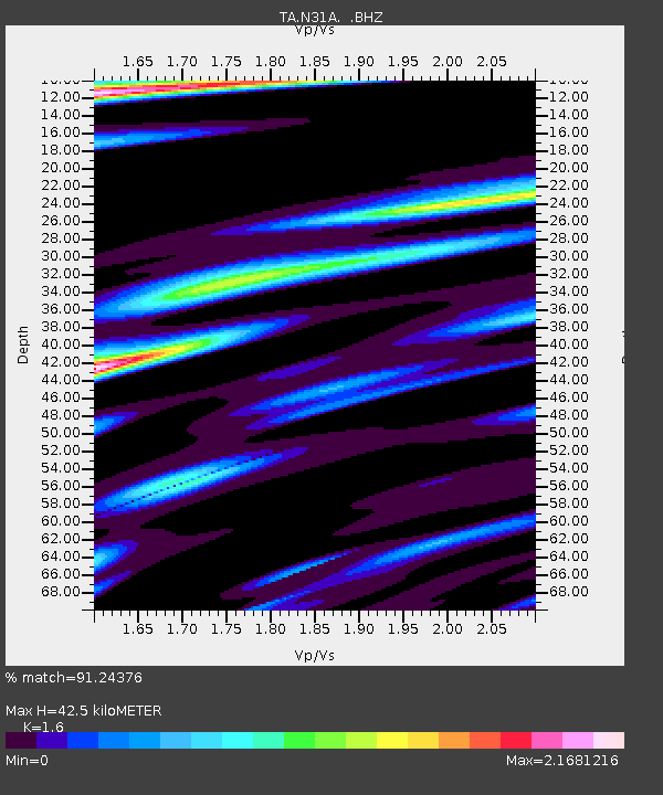
| Estimated Moho Depth: |
42.5 km |
| Estimated Crust Vp/Vs: |
1.60 |
| Assumed Crust Vp: |
6.53 km/s |
| Estimated Crust Vs: |
4.082 km/s |
| Estimated Crust Poisson's Ratio: |
0.18 |
|
| Radial Match: |
91.24376 % |
| Radial Bump: |
345 |
| Transverse Match: |
79.44751 % |
| Transverse Bump: |
400 |
| SOD ConfigId: |
314592 |
| Insert Time: |
2010-09-04 07:41:32.022 +0000 |
| GWidth: |
2.5 |
| Max Bumps: |
400 |
| Tol: |
0.001 |
|
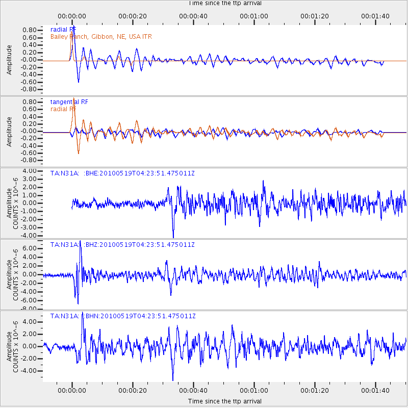
Signal To Noise
| Channel | StoN | STA | LTA |
| TA:N31A: :BHZ:20100519T04:23:51.475011Z | 19.896526 | 3.0809556E-6 | 1.5484892E-7 |
| TA:N31A: :BHN:20100519T04:23:51.475011Z | 5.9927816 | 2.0119103E-6 | 3.3572226E-7 |
| TA:N31A: :BHE:20100519T04:23:51.475011Z | 4.9771166 | 1.3874444E-6 | 2.787647E-7 |
| Arrivals |
| Ps | 4.2 SECOND |
| PpPs | 16 SECOND |
| PsPs/PpSs | 20 SECOND |


