You are here: Home > Network List > TX - Texas Seismological Network Stations List
> Station BRDY Brady > Earthquake Result Viewer
BRDY Brady - Earthquake Result Viewer
| Earthquake location: |
Tonga Islands Region |
| Earthquake latitude/longitude: |
-23.8/-175.7 |
| Earthquake time(UTC): |
2023/06/18 (169) 15:04:49 GMT |
| Earthquake Depth: |
10 km |
| Earthquake Magnitude: |
5.8 Mww |
| Earthquake Catalog/Contributor: |
NEIC PDE/us |
|
| Network: |
TX Texas Seismological Network |
| Station: |
BRDY Brady |
| Lat/Lon: |
31.27 N/99.00 W |
| Elevation: |
460 m |
|
| Distance: |
91.5 deg |
| Az: |
56.482 deg |
| Baz: |
243.128 deg |
| Ray Param: |
0.041593257 |
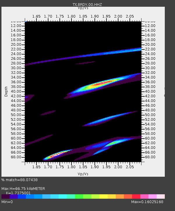
| Estimated Moho Depth: |
66.75 km |
| Estimated Crust Vp/Vs: |
1.74 |
| Assumed Crust Vp: |
6.498 km/s |
| Estimated Crust Vs: |
3.74 km/s |
| Estimated Crust Poisson's Ratio: |
0.25 |
|
| Radial Match: |
88.07438 % |
| Radial Bump: |
400 |
| Transverse Match: |
62.171246 % |
| Transverse Bump: |
400 |
| SOD ConfigId: |
30536071 |
| Insert Time: |
2023-07-02 15:23:43.877 +0000 |
| GWidth: |
2.5 |
| Max Bumps: |
400 |
| Tol: |
0.001 |
|

Signal To Noise
| Channel | StoN | STA | LTA |
| TX:BRDY:00:HHZ:20230618T15:17:24.920004Z | 0.9646047 | 3.970476E-7 | 4.116169E-7 |
| TX:BRDY:00:HH1:20230618T15:17:24.920004Z | 1.8203185 | 3.7362275E-7 | 2.0525131E-7 |
| TX:BRDY:00:HH2:20230618T15:17:24.920004Z | 1.6749387 | 3.6382443E-7 | 2.1721657E-7 |
| Arrivals |
| Ps | 7.7 SECOND |
| PpPs | 28 SECOND |
| PsPs/PpSs | 35 SECOND |


