You are here: Home > Network List > GS - US Geological Survey Networks Stations List
> Station KAN10 Keim Farm > Earthquake Result Viewer
KAN10 Keim Farm - Earthquake Result Viewer

| Earthquake location: |
Tonga Islands |
| Earthquake latitude/longitude: |
-20.5/-173.8 |
| Earthquake time(UTC): |
2018/11/10 (314) 08:33:16 GMT |
| Earthquake Depth: |
10 km |
| Earthquake Magnitude: |
6.2 Mww |
| Earthquake Catalog/Contributor: |
NEIC PDE/us |
|
| Network: |
GS US Geological Survey Networks |
| Station: |
KAN10 Keim Farm |
| Lat/Lon: |
37.12 N/98.10 W |
| Elevation: |
417 m |
|
| Distance: |
91.4 deg |
| Az: |
50.79 deg |
| Baz: |
245.308 deg |
| Ray Param: |
0.041603092 |
| Estimated Moho Depth: |
50.75 km |
| Estimated Crust Vp/Vs: |
1.96 |
| Assumed Crust Vp: |
6.426 km/s |
| Estimated Crust Vs: |
3.283 km/s |
| Estimated Crust Poisson's Ratio: |
0.32 |
|
| Radial Match: |
99.14035 % |
| Radial Bump: |
48 |
| Transverse Match: |
98.32373 % |
| Transverse Bump: |
138 |
| SOD ConfigId: |
3131071 |
| Insert Time: |
2018-11-24 08:42:15.552 +0000 |
| GWidth: |
2.5 |
| Max Bumps: |
400 |
| Tol: |
0.001 |
|
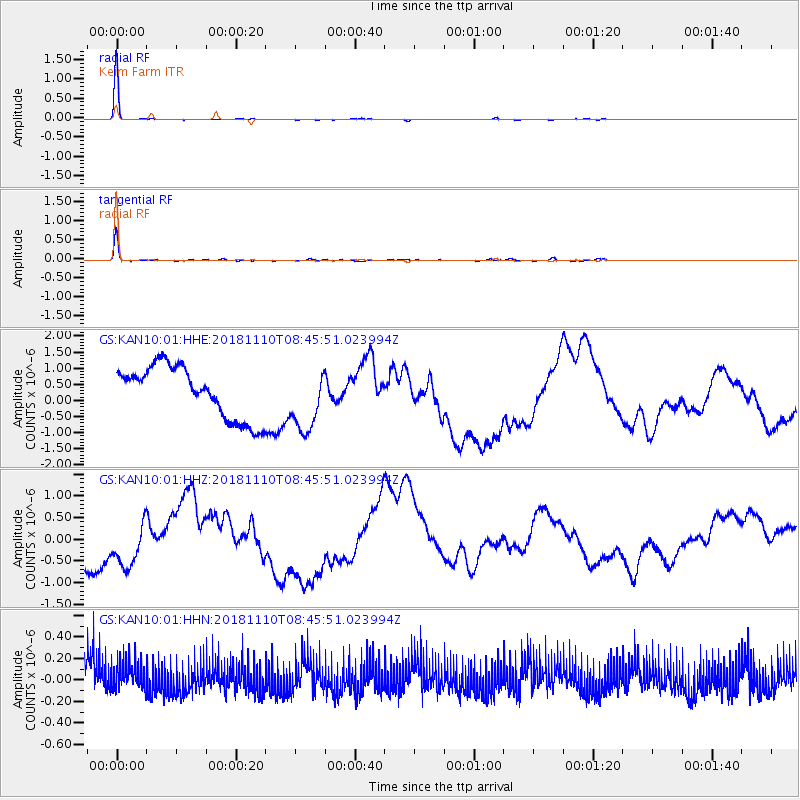
Signal To Noise
| Channel | StoN | STA | LTA |
| GS:KAN10:01:HHZ:20181110T08:45:51.023994Z | 1.1927812 | 6.5602376E-7 | 5.4999504E-7 |
| GS:KAN10:01:HHN:20181110T08:45:51.023994Z | 0.9251754 | 1.2210133E-7 | 1.319764E-7 |
| GS:KAN10:01:HHE:20181110T08:45:51.023994Z | 1.2152396 | 9.756114E-7 | 8.0281404E-7 |
| Arrivals |
| Ps | 7.7 SECOND |
| PpPs | 23 SECOND |
| PsPs/PpSs | 31 SECOND |


