You are here: Home > Network List > 1E - GSC-BCOGC Induced Seismicity Study Stations List
> Station MONT4 Z > Earthquake Result Viewer
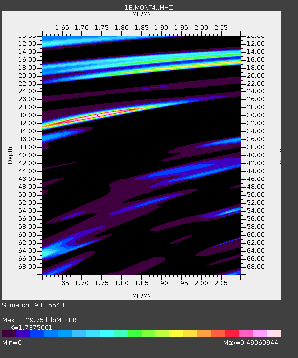
MONT4 Z - Earthquake Result Viewer
| Earthquake location: |
Gulf Of California |
| Earthquake latitude/longitude: |
23.2/-108.3 |
| Earthquake time(UTC): |
2023/06/18 (169) 20:30:30 GMT |
| Earthquake Depth: |
33 km |
| Earthquake Magnitude: |
6.6 Mi |
| Earthquake Catalog/Contributor: |
NEIC PDE/at |
|
| Network: |
1E GSC-BCOGC Induced Seismicity Study |
| Station: |
MONT4 Z |
| Lat/Lon: |
57.32 N/122.71 W |
| Elevation: |
1110 m |
|
| Distance: |
35.7 deg |
| Az: |
346.611 deg |
| Baz: |
156.878 deg |
| Ray Param: |
0.07704527 |
| Estimated Moho Depth: |
29.75 km |
| Estimated Crust Vp/Vs: |
1.74 |
| Assumed Crust Vp: |
6.232 km/s |
| Estimated Crust Vs: |
3.587 km/s |
| Estimated Crust Poisson's Ratio: |
0.25 |
|
| Radial Match: |
93.15548 % |
| Radial Bump: |
272 |
| Transverse Match: |
66.58005 % |
| Transverse Bump: |
400 |
| SOD ConfigId: |
30536071 |
| Insert Time: |
2023-07-02 20:31:48.440 +0000 |
| GWidth: |
2.5 |
| Max Bumps: |
400 |
| Tol: |
0.001 |
|

Signal To Noise
| Channel | StoN | STA | LTA |
| 1E:MONT4: :HHZ:20230618T20:36:54.540009Z | 2.6414182 | 5.753007E-7 | 2.1779994E-7 |
| 1E:MONT4: :HHN:20230618T20:36:54.540009Z | 3.1414323 | 6.0886447E-7 | 1.9381746E-7 |
| 1E:MONT4: :HHE:20230618T20:36:54.540009Z | 2.2371306 | 4.323149E-7 | 1.9324527E-7 |
| Arrivals |
| Ps | 3.8 SECOND |
| PpPs | 12 SECOND |
| PsPs/PpSs | 16 SECOND |


