You are here: Home > Network List > 1E - GSC-BCOGC Induced Seismicity Study Stations List
> Station MONT5 Z > Earthquake Result Viewer
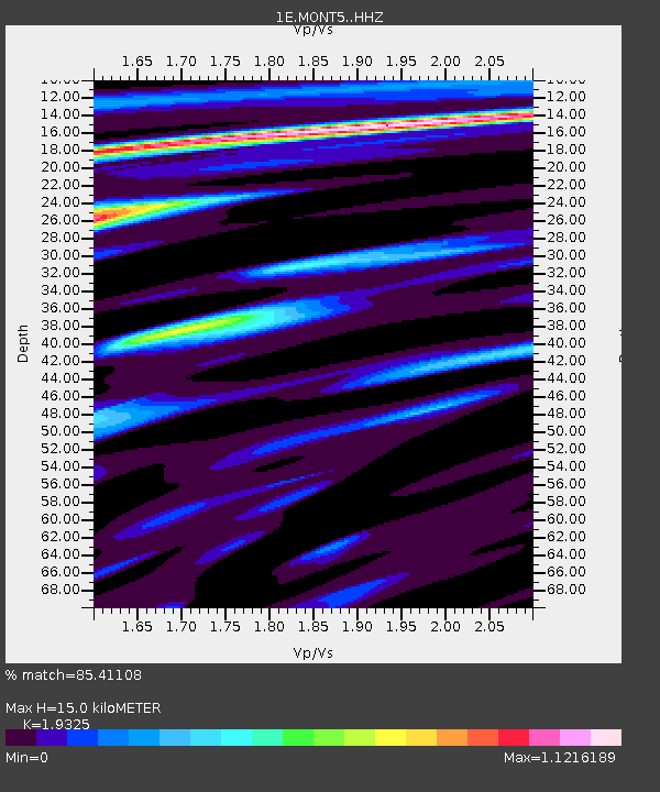
MONT5 Z - Earthquake Result Viewer
| Earthquake location: |
Gulf Of California |
| Earthquake latitude/longitude: |
23.2/-108.3 |
| Earthquake time(UTC): |
2023/06/18 (169) 20:30:30 GMT |
| Earthquake Depth: |
33 km |
| Earthquake Magnitude: |
6.6 Mi |
| Earthquake Catalog/Contributor: |
NEIC PDE/at |
|
| Network: |
1E GSC-BCOGC Induced Seismicity Study |
| Station: |
MONT5 Z |
| Lat/Lon: |
57.03 N/122.34 W |
| Elevation: |
1097 m |
|
| Distance: |
35.3 deg |
| Az: |
346.735 deg |
| Baz: |
157.288 deg |
| Ray Param: |
0.077233724 |
| Estimated Moho Depth: |
15.0 km |
| Estimated Crust Vp/Vs: |
1.93 |
| Assumed Crust Vp: |
6.232 km/s |
| Estimated Crust Vs: |
3.225 km/s |
| Estimated Crust Poisson's Ratio: |
0.32 |
|
| Radial Match: |
85.41108 % |
| Radial Bump: |
400 |
| Transverse Match: |
83.64934 % |
| Transverse Bump: |
400 |
| SOD ConfigId: |
30536071 |
| Insert Time: |
2023-07-02 20:31:52.100 +0000 |
| GWidth: |
2.5 |
| Max Bumps: |
400 |
| Tol: |
0.001 |
|

Signal To Noise
| Channel | StoN | STA | LTA |
| 1E:MONT5: :HHZ:20230618T20:36:51.570007Z | 7.267051 | 1.2203936E-6 | 1.679352E-7 |
| 1E:MONT5: :HHN:20230618T20:36:51.570007Z | 2.7971988 | 3.4843438E-7 | 1.2456547E-7 |
| 1E:MONT5: :HHE:20230618T20:36:51.570007Z | 2.5800657 | 5.3181594E-7 | 2.0612495E-7 |
| Arrivals |
| Ps | 2.4 SECOND |
| PpPs | 6.6 SECOND |
| PsPs/PpSs | 9.0 SECOND |


