You are here: Home > Network List > AK - Alaska Regional Network Stations List
> Station B22K Teshekpuk Lake, AK, USA > Earthquake Result Viewer
B22K Teshekpuk Lake, AK, USA - Earthquake Result Viewer
| Earthquake location: |
Gulf Of California |
| Earthquake latitude/longitude: |
23.2/-108.3 |
| Earthquake time(UTC): |
2023/06/18 (169) 20:30:30 GMT |
| Earthquake Depth: |
33 km |
| Earthquake Magnitude: |
6.6 Mi |
| Earthquake Catalog/Contributor: |
NEIC PDE/at |
|
| Network: |
AK Alaska Regional Network |
| Station: |
B22K Teshekpuk Lake, AK, USA |
| Lat/Lon: |
70.34 N/153.42 W |
| Elevation: |
50 m |
|
| Distance: |
54.0 deg |
| Az: |
342.748 deg |
| Baz: |
126.268 deg |
| Ray Param: |
0.065688 |
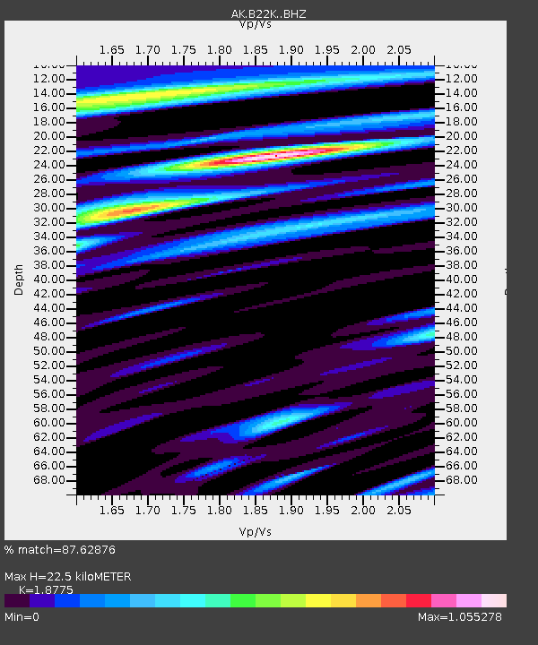
| Estimated Moho Depth: |
22.5 km |
| Estimated Crust Vp/Vs: |
1.88 |
| Assumed Crust Vp: |
5.738 km/s |
| Estimated Crust Vs: |
3.056 km/s |
| Estimated Crust Poisson's Ratio: |
0.30 |
|
| Radial Match: |
87.62876 % |
| Radial Bump: |
400 |
| Transverse Match: |
77.30833 % |
| Transverse Bump: |
400 |
| SOD ConfigId: |
30536071 |
| Insert Time: |
2023-07-02 20:32:26.583 +0000 |
| GWidth: |
2.5 |
| Max Bumps: |
400 |
| Tol: |
0.001 |
|

Signal To Noise
| Channel | StoN | STA | LTA |
| AK:B22K: :BHZ:20230618T20:39:19.919983Z | 9.662249 | 8.7000456E-7 | 9.0041624E-8 |
| AK:B22K: :BHN:20230618T20:39:19.919983Z | 2.0702462 | 2.4293922E-7 | 1.1734799E-7 |
| AK:B22K: :BHE:20230618T20:39:19.919983Z | 1.626298 | 2.3442117E-7 | 1.4414404E-7 |
| Arrivals |
| Ps | 3.6 SECOND |
| PpPs | 11 SECOND |
| PsPs/PpSs | 14 SECOND |


