You are here: Home > Network List > AK - Alaska Regional Network Stations List
> Station N18K Kilae Creek, AK, USA > Earthquake Result Viewer
N18K Kilae Creek, AK, USA - Earthquake Result Viewer
| Earthquake location: |
Gulf Of California |
| Earthquake latitude/longitude: |
23.2/-108.3 |
| Earthquake time(UTC): |
2023/06/18 (169) 20:30:30 GMT |
| Earthquake Depth: |
33 km |
| Earthquake Magnitude: |
6.6 Mi |
| Earthquake Catalog/Contributor: |
NEIC PDE/at |
|
| Network: |
AK Alaska Regional Network |
| Station: |
N18K Kilae Creek, AK, USA |
| Lat/Lon: |
60.68 N/155.89 W |
| Elevation: |
572 m |
|
| Distance: |
49.7 deg |
| Az: |
331.557 deg |
| Baz: |
117.083 deg |
| Ray Param: |
0.06846612 |
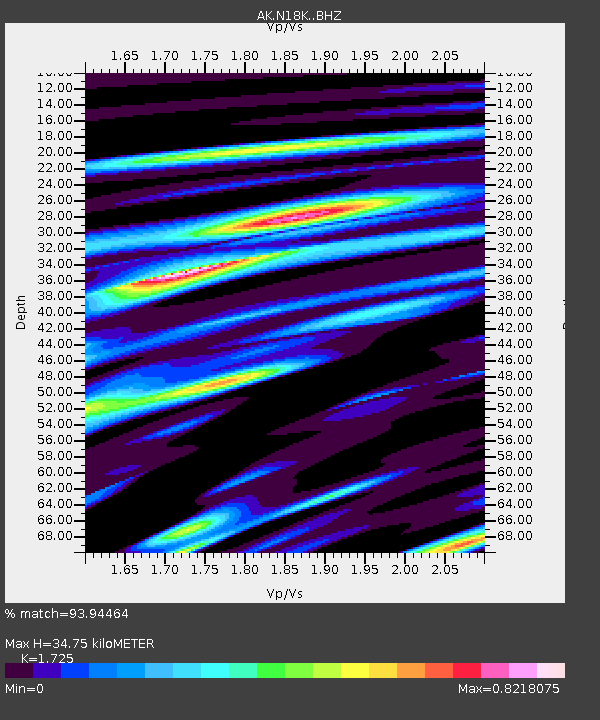
| Estimated Moho Depth: |
34.75 km |
| Estimated Crust Vp/Vs: |
1.73 |
| Assumed Crust Vp: |
6.566 km/s |
| Estimated Crust Vs: |
3.806 km/s |
| Estimated Crust Poisson's Ratio: |
0.25 |
|
| Radial Match: |
93.94464 % |
| Radial Bump: |
328 |
| Transverse Match: |
90.19592 % |
| Transverse Bump: |
400 |
| SOD ConfigId: |
30536071 |
| Insert Time: |
2023-07-02 20:35:00.808 +0000 |
| GWidth: |
2.5 |
| Max Bumps: |
400 |
| Tol: |
0.001 |
|

Signal To Noise
| Channel | StoN | STA | LTA |
| AK:N18K: :BHZ:20230618T20:38:48.440002Z | 12.176888 | 7.94424E-7 | 6.5240314E-8 |
| AK:N18K: :BHN:20230618T20:38:48.440002Z | 1.713354 | 1.8652047E-7 | 1.0886277E-7 |
| AK:N18K: :BHE:20230618T20:38:48.440002Z | 7.069265 | 5.1538035E-7 | 7.2904385E-8 |
| Arrivals |
| Ps | 4.1 SECOND |
| PpPs | 14 SECOND |
| PsPs/PpSs | 18 SECOND |


