You are here: Home > Network List > AT - Alaska Tsunami Warning Seismic System Stations List
> Station TTA Tatalina, Alaska > Earthquake Result Viewer
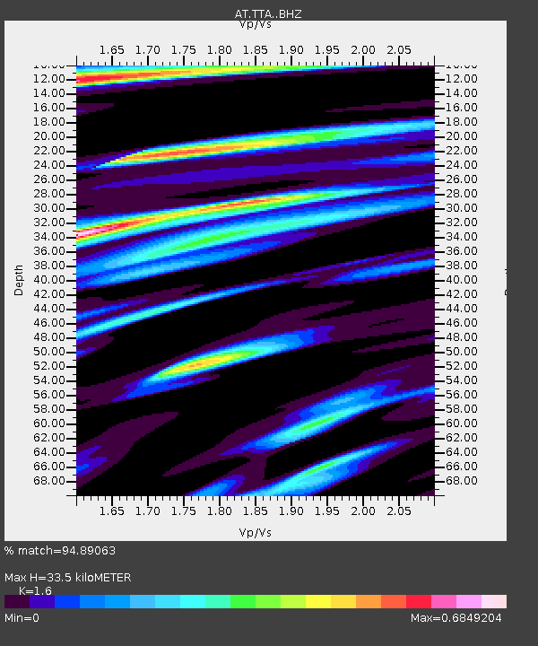
TTA Tatalina, Alaska - Earthquake Result Viewer
| Earthquake location: |
Gulf Of California |
| Earthquake latitude/longitude: |
23.2/-108.3 |
| Earthquake time(UTC): |
2023/06/18 (169) 20:30:30 GMT |
| Earthquake Depth: |
33 km |
| Earthquake Magnitude: |
6.6 Mi |
| Earthquake Catalog/Contributor: |
NEIC PDE/at |
|
| Network: |
AT Alaska Tsunami Warning Seismic System |
| Station: |
TTA Tatalina, Alaska |
| Lat/Lon: |
62.93 N/156.01 W |
| Elevation: |
990 m |
|
| Distance: |
50.8 deg |
| Az: |
334.118 deg |
| Baz: |
118.612 deg |
| Ray Param: |
0.06773597 |
| Estimated Moho Depth: |
33.5 km |
| Estimated Crust Vp/Vs: |
1.60 |
| Assumed Crust Vp: |
6.182 km/s |
| Estimated Crust Vs: |
3.864 km/s |
| Estimated Crust Poisson's Ratio: |
0.18 |
|
| Radial Match: |
94.89063 % |
| Radial Bump: |
328 |
| Transverse Match: |
88.33794 % |
| Transverse Bump: |
400 |
| SOD ConfigId: |
30536071 |
| Insert Time: |
2023-07-02 20:36:18.297 +0000 |
| GWidth: |
2.5 |
| Max Bumps: |
400 |
| Tol: |
0.001 |
|

Signal To Noise
| Channel | StoN | STA | LTA |
| AT:TTA: :BHZ:20230618T20:38:56.779999Z | 10.045204 | 7.2411655E-7 | 7.20858E-8 |
| AT:TTA: :BHN:20230618T20:38:56.779999Z | 3.1919236 | 2.8091404E-7 | 8.800776E-8 |
| AT:TTA: :BHE:20230618T20:38:56.779999Z | 3.8279338 | 3.023453E-7 | 7.8983945E-8 |
| Arrivals |
| Ps | 3.4 SECOND |
| PpPs | 13 SECOND |
| PsPs/PpSs | 17 SECOND |


