You are here: Home > Network List > TA - USArray Transportable Network (new EarthScope stations) Stations List
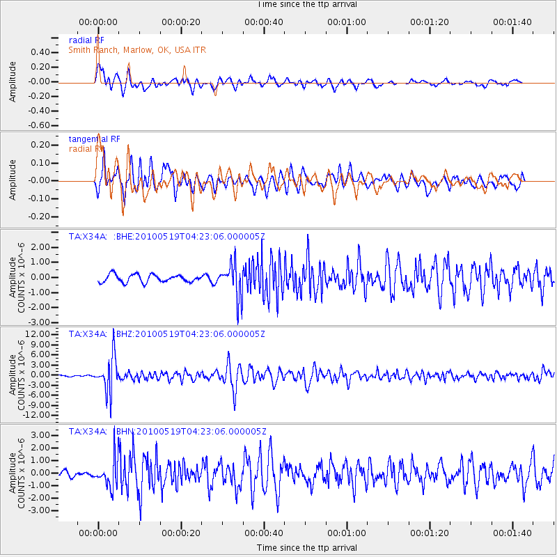
> Station X34A Smith Ranch, Marlow, OK, USA > Earthquake Result Viewer
X34A Smith Ranch, Marlow, OK, USA - Earthquake Result Viewer
| Earthquake location: |
Northern Peru |
| Earthquake latitude/longitude: |
-5.1/-77.5 |
| Earthquake time(UTC): |
2010/05/19 (139) 04:15:44 GMT |
| Earthquake Depth: |
140 km |
| Earthquake Magnitude: |
6.0 MB, 6.0 MW, 6.0 MW |
| Earthquake Catalog/Contributor: |
WHDF/NEIC |
|
| Network: |
TA USArray Transportable Network (new EarthScope stations) |
| Station: |
X34A Smith Ranch, Marlow, OK, USA |
| Lat/Lon: |
34.60 N/97.83 W |
| Elevation: |
364 m |
|
| Distance: |
43.9 deg |
| Az: |
335.609 deg |
| Baz: |
150.087 deg |
| Ray Param: |
0.07177621 |
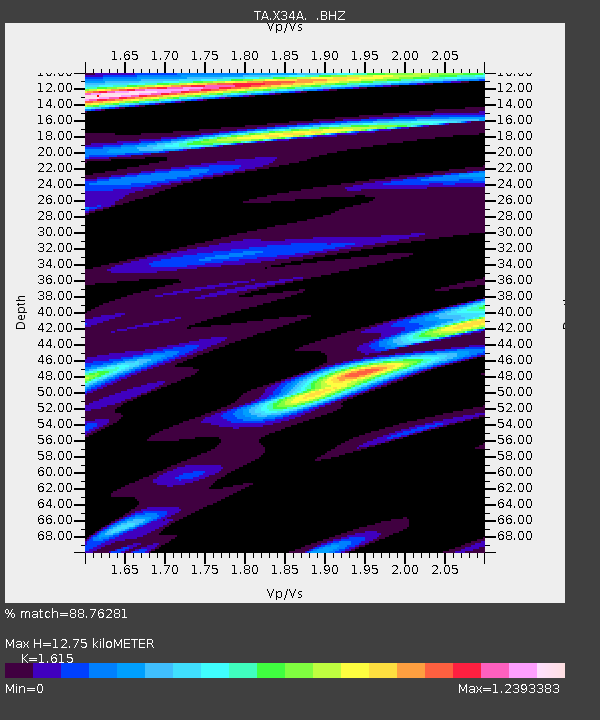
| Estimated Moho Depth: |
12.75 km |
| Estimated Crust Vp/Vs: |
1.62 |
| Assumed Crust Vp: |
6.426 km/s |
| Estimated Crust Vs: |
3.979 km/s |
| Estimated Crust Poisson's Ratio: |
0.19 |
|
| Radial Match: |
88.76281 % |
| Radial Bump: |
400 |
| Transverse Match: |
80.751945 % |
| Transverse Bump: |
400 |
| SOD ConfigId: |
314592 |
| Insert Time: |
2010-09-04 07:44:11.349 +0000 |
| GWidth: |
2.5 |
| Max Bumps: |
400 |
| Tol: |
0.001 |
|
Signal To Noise
| Channel | StoN | STA | LTA |
| TA:X34A: :BHZ:20100519T04:23:06.000005Z | 31.945444 | 5.261849E-6 | 1.647136E-7 |
| TA:X34A: :BHN:20100519T04:23:06.000005Z | 5.7808046 | 1.1643685E-6 | 2.0141981E-7 |
| TA:X34A: :BHE:20100519T04:23:06.000005Z | 4.364947 | 1.1259311E-6 | 2.5794841E-7 |
| Arrivals |
| Ps | 1.3 SECOND |
| PpPs | 4.8 SECOND |
| PsPs/PpSs | 6.1 SECOND |


