You are here: Home > Network List > AV - Alaska Volcano Observatory Stations List
> Station KAWH Katmai, Alaska > Earthquake Result Viewer
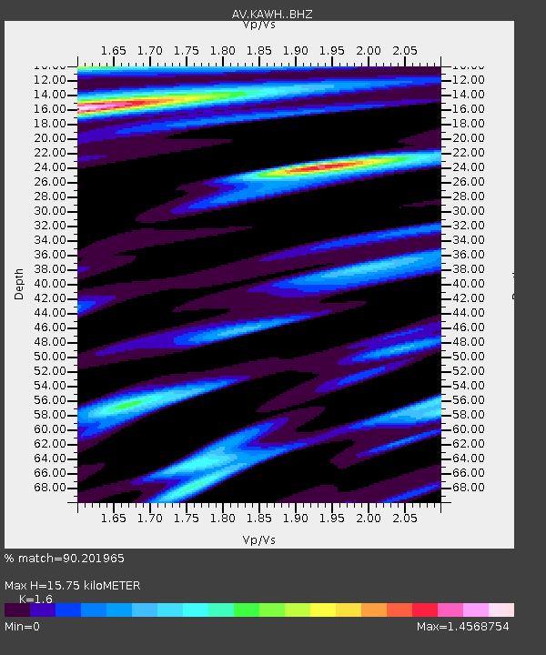
KAWH Katmai, Alaska - Earthquake Result Viewer
| Earthquake location: |
Gulf Of California |
| Earthquake latitude/longitude: |
23.2/-108.3 |
| Earthquake time(UTC): |
2023/06/18 (169) 20:30:30 GMT |
| Earthquake Depth: |
33 km |
| Earthquake Magnitude: |
6.6 Mi |
| Earthquake Catalog/Contributor: |
NEIC PDE/at |
|
| Network: |
AV Alaska Volcano Observatory |
| Station: |
KAWH Katmai, Alaska |
| Lat/Lon: |
58.38 N/154.80 W |
| Elevation: |
777 m |
|
| Distance: |
48.2 deg |
| Az: |
329.161 deg |
| Baz: |
116.446 deg |
| Ray Param: |
0.06945791 |
| Estimated Moho Depth: |
15.75 km |
| Estimated Crust Vp/Vs: |
1.60 |
| Assumed Crust Vp: |
6.438 km/s |
| Estimated Crust Vs: |
4.024 km/s |
| Estimated Crust Poisson's Ratio: |
0.18 |
|
| Radial Match: |
90.201965 % |
| Radial Bump: |
400 |
| Transverse Match: |
83.15692 % |
| Transverse Bump: |
400 |
| SOD ConfigId: |
30536071 |
| Insert Time: |
2023-07-02 20:37:22.200 +0000 |
| GWidth: |
2.5 |
| Max Bumps: |
400 |
| Tol: |
0.001 |
|

Signal To Noise
| Channel | StoN | STA | LTA |
| AV:KAWH: :BHZ:20230618T20:38:36.700012Z | 8.066367 | 6.232245E-7 | 7.7262094E-8 |
| AV:KAWH: :BHN:20230618T20:38:36.700012Z | 1.2787132 | 1.3539758E-7 | 1.0588581E-7 |
| AV:KAWH: :BHE:20230618T20:38:36.700012Z | 3.2079728 | 2.3684106E-7 | 7.3828886E-8 |
| Arrivals |
| Ps | 1.6 SECOND |
| PpPs | 5.9 SECOND |
| PsPs/PpSs | 7.5 SECOND |


