You are here: Home > Network List > TA - USArray Transportable Network (new EarthScope stations) Stations List
> Station 534A Blanco, TX, USA > Earthquake Result Viewer
534A Blanco, TX, USA - Earthquake Result Viewer
| Earthquake location: |
Northern Peru |
| Earthquake latitude/longitude: |
-5.1/-77.5 |
| Earthquake time(UTC): |
2010/05/19 (139) 04:15:44 GMT |
| Earthquake Depth: |
140 km |
| Earthquake Magnitude: |
6.0 MB, 6.0 MW, 6.0 MW |
| Earthquake Catalog/Contributor: |
WHDF/NEIC |
|
| Network: |
TA USArray Transportable Network (new EarthScope stations) |
| Station: |
534A Blanco, TX, USA |
| Lat/Lon: |
30.03 N/98.48 W |
| Elevation: |
461 m |
|
| Distance: |
40.3 deg |
| Az: |
331.345 deg |
| Baz: |
146.577 deg |
| Ray Param: |
0.07399926 |
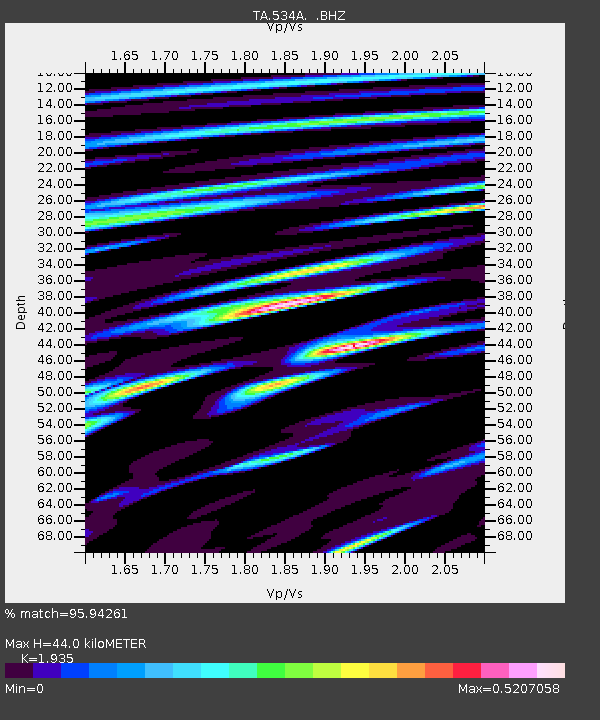
| Estimated Moho Depth: |
44.0 km |
| Estimated Crust Vp/Vs: |
1.93 |
| Assumed Crust Vp: |
6.498 km/s |
| Estimated Crust Vs: |
3.358 km/s |
| Estimated Crust Poisson's Ratio: |
0.32 |
|
| Radial Match: |
95.94261 % |
| Radial Bump: |
400 |
| Transverse Match: |
76.336044 % |
| Transverse Bump: |
400 |
| SOD ConfigId: |
314592 |
| Insert Time: |
2010-09-04 07:44:28.029 +0000 |
| GWidth: |
2.5 |
| Max Bumps: |
400 |
| Tol: |
0.001 |
|
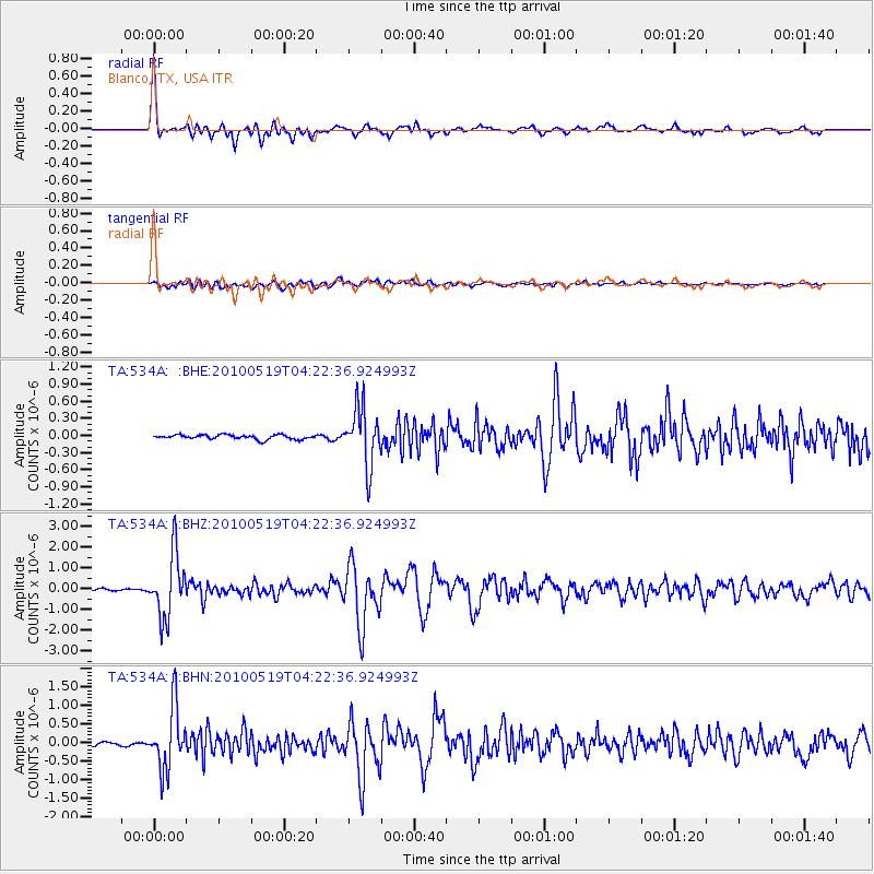
Signal To Noise
| Channel | StoN | STA | LTA |
| TA:534A: :BHZ:20100519T04:22:36.924993Z | 37.669567 | 1.5067515E-6 | 3.999917E-8 |
| TA:534A: :BHN:20100519T04:22:36.924993Z | 15.597416 | 8.378224E-7 | 5.3715464E-8 |
| TA:534A: :BHE:20100519T04:22:36.924993Z | 12.679808 | 5.011918E-7 | 3.9526764E-8 |
| Arrivals |
| Ps | 6.8 SECOND |
| PpPs | 19 SECOND |
| PsPs/PpSs | 25 SECOND |


